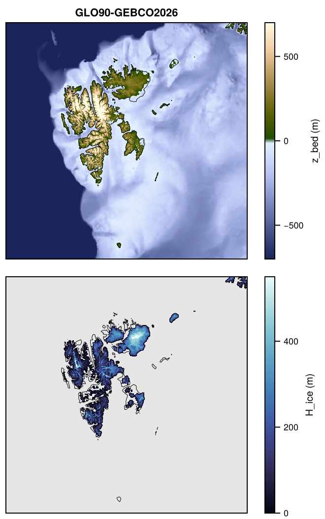
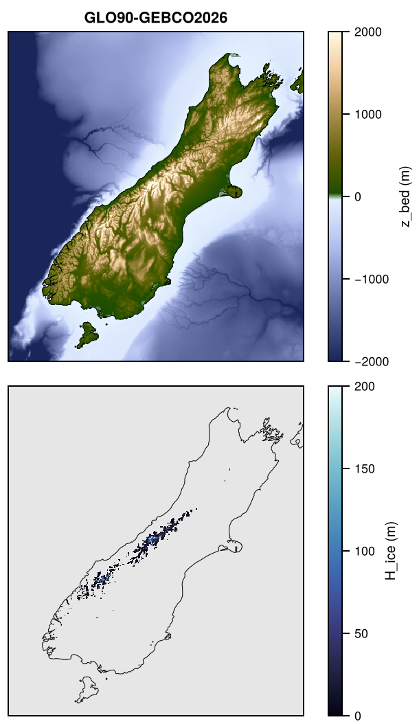
Topo: high-resolution topography

Bed topography, surface elevation, ice thickness and the area fractions of ocean, land and ice on every grid of every active domain, from the base grid (25 m to 2 km) to the coarsest grid, merged from the best available sources: BedMachine and Bedmap3 for the ice sheets, GEBCO 2026 for the ocean and the rest of the land, and the Copernicus DEM and the IceBoost glacier thicknesses for the mountain glaciers. Topo is made by a pipeline of its own; the Products page shows its versions on each domain, the Domains page the domains and grids.

Products

Each domain has default products, from the latest sources, and variants, from earlier versions of the ice-sheet datasets or other sources; both are released. The sources of a product are merged in order of priority, the first over the others:

Product Sources, by priority Domains
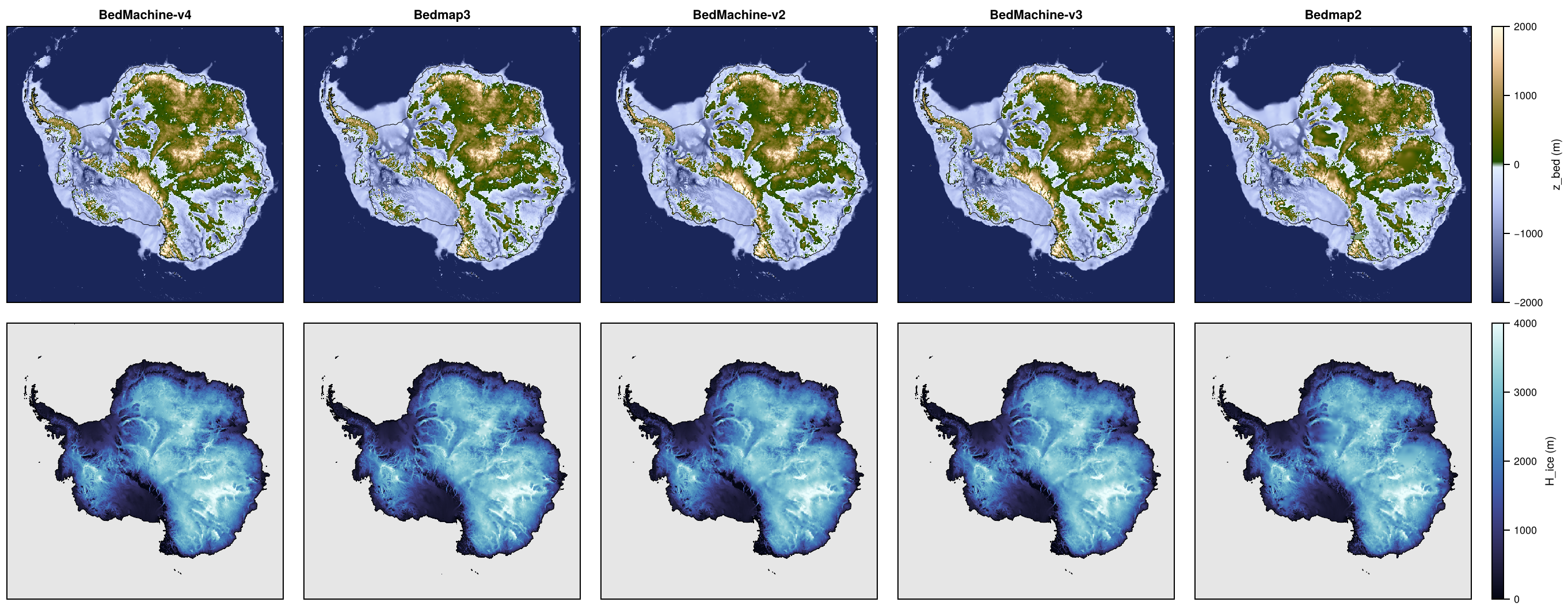
TOPO-BedMachine-v4 BedMachine Antarctica v4, GEBCO 2026 Antarctica and its crops
TOPO-Bedmap3 Bedmap3, GEBCO 2026 Antarctica and its crops
TOPO-BedMachine-v6 BedMachine Greenland v6, GEBCO 2026 GreenlandPaleo, Greenland, Jakobshavn, NEGIS, Petermann, Helheim
TOPO-GEBCO2026 BedMachine Greenland v6, IceBoost v2.0, GEBCO 2026 North, Laurentide, Eurasia
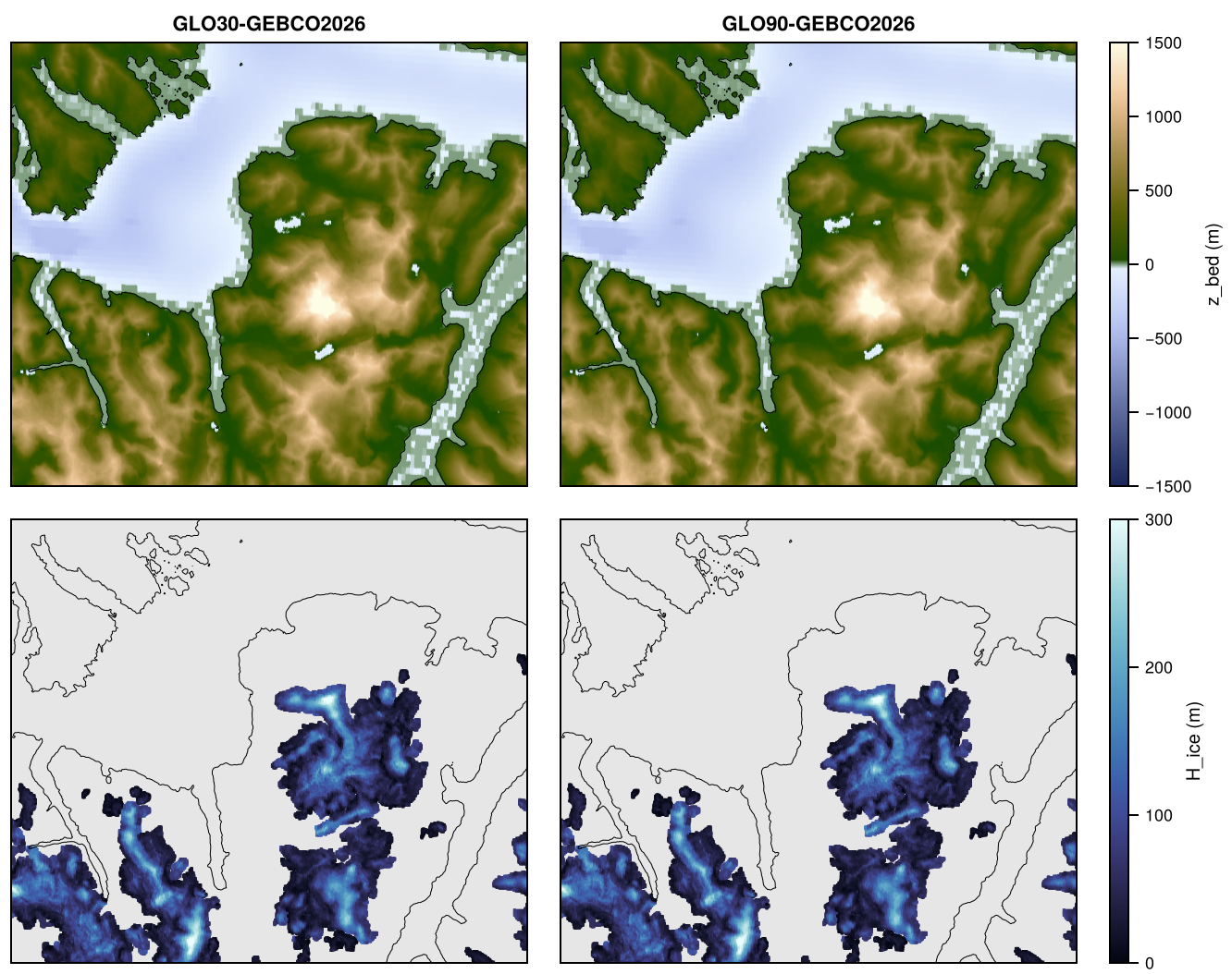
TOPO-GLO30-GEBCO2026 IceBoost v2.0, Copernicus DEM GLO-30, GEBCO 2026 SRG, MonteSarmiento, SchiaparelliGlacier, DrangDrung
TOPO-GLO90-GEBCO2026 IceBoost v2.0, Copernicus DEM GLO-90, GEBCO 2026 Pyrenees, Patagonia, NorthPatagonianIcefield, SouthPatagonianIcefield, GranCampoNevado, CordilleraDarwin, Himalaya, Alps, Svalbard, NewZealand

Variants:

Product Sources, by priority Domains
TOPO-BedMachine-v3, TOPO-BedMachine-v2 BedMachine Antarctica v3, v2, GEBCO 2026 Antarctica and its crops, 1 km and coarser
TOPO-Bedmap2 Bedmap2, GEBCO 2026 Antarctica and its crops, 1 km and coarser
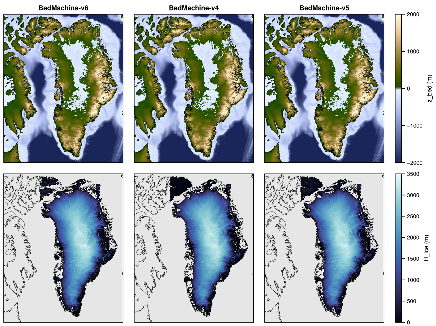
TOPO-BedMachine-v5, TOPO-BedMachine-v4 BedMachine Greenland v5, v4, GEBCO 2026 GreenlandPaleo, Greenland
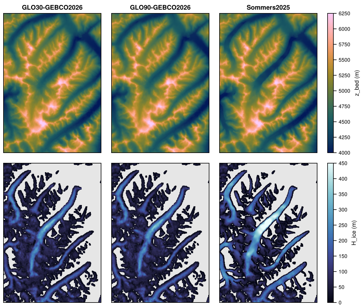
TOPO-Sommers2025 Sommers (2025) surface and Millan et al. (2022) thickness, IceBoost v2.0, Copernicus DEM GLO-30, GEBCO 2026 DrangDrung
TOPO-GLO90-GEBCO2026 IceBoost v2.0, Copernicus DEM GLO-90, GEBCO 2026 SRG, MonteSarmiento, DrangDrung

The variants of Antarctica are merged on ANT-500M, but written only on the grids of 1 km and coarser (variants_resolution in products.toml). The files are <GRID>_TOPO-<product>.nc, with the fields:

Field Units Contents
z_bed m Bed elevation (cell mean)
z_srf m Surface elevation (cell mean; 0 over the ocean; in Antarctica including firn air)
H_ice m Ice thickness (cell mean)
z_bed_sd m Standard deviation of the bed elevation within the cell
f_ocn, f_land, f_grnd, f_flt 1 Area fractions of ice-free ocean, ice-free land, grounded ice and floating ice
mask Dominant surface type: 0 ocean, 1 ice-free land, 2 grounded ice, 3 floating ice
src_id Source with the largest weight in the cell (names in flag_meanings)

The global attributes product and sources give the product and its sources, by priority.

Method

The processing has two stages:

  1. Sources → base grid. Each source is remapped once onto the base grid of a domain (e.g. ANT-500M, GRL-PAL-500M, NH-2KM, PAT-250M, SRG-25M), and the sources are then merged in order of priority (e.g. BedMachine over GEBCO).
  2. Base → all other grids. Every coarser grid, and the crops of a domain (e.g. GRL, LIS, EIS, ASE, THW, NPI, SPI), is remapped from the merged base product.

Remapping is conservative: exact for sources on the same projection as the domain (BedMachine, Bedmap3), and from sub-cell sampling for sources on other grids (GEBCO, Copernicus DEM tiles, IceBoost glacier tiles, the Drang Drung data in UTM). The methods are in FesmUtils.jl and are threaded.

Sources on the base grid

Each source is remapped onto the base grid as z_bed, z_srf, H_ice, z_bed_sd (sub-cell standard deviation of the bed), the area fractions f_ocn, f_land, f_grnd, f_flt, and f_valid (fraction of the cell covered by the source). Sources on the domain projection (BedMachine, Bedmap3) are remapped exactly; GEBCO, and projected sources on another projection (the Drang Drung data), are sampled at about half their resolution within each cell.

Land sources (the Copernicus DEMs GLO-90 and GLO-30) give only the elevation of the land, as 1-degree lon-lat tiles. Each tile overlapping the base grid is remapped exactly conservatively onto the base cells it covers: every pixel, a quadrilateral on the projection of the domain, is weighted by its area in each cell. The file has z_land (mean land elevation), f_land (land fraction; elevations at or below 0 m are ocean), f_valid (fraction covered by the tiles) and z_land_sd, the standard deviation of the land elevation within the cell, from the bilinear interpolation of the pixels sampled at most half a pixel apart and at least 4 x 4 times per cell. On cells smaller than about two pixels, the spread of the pixels themselves would show the pixel lattice beating against the grid (stripes in z_bed_sd on the 25-50 m grids); that of the interpolated surface varies smoothly, and tends there to the resolved slope times the cell size over sqrt(12).

Thickness sources (IceBoost) give only glacier ice thickness, as one tile per glacier on its own projection (UTM). Each tile is sampled at about half its resolution within the base cells it covers, and the file has H_ice (cell mean, 0 off the glaciers) and f_ice (glacier area fraction). The pixels touched by a glacier outline count as glacier in the tiles, so the thickness and area of each tile are scaled to the glacier volume and area given with it (the raw pixels give 2% more volume and 3-6% more area). Tiles still overlap along shared ice divides: where their glacier fractions add up to more than 1, the cell is shared, its glacier fraction and thickness divided by that sum, so that the overlap is not counted twice (this matters on grids of 50-250 m, where a boundary is a large part of a cell). The job log compares the glacier area and volume with those of the tiles, before and after.

Only the tiles overlapping the base grid are read (threaded). Their grids and latitude ranges, from the file headers, are kept in an index per RGI region ($FESMDATA_WORK/topo/tiles/iceboost_v2_rgiNN.tsv), which the first IceBoost job builds in about 5 min, and rebuilds when the files of a region change. With the index, IceBoost takes under a minute for PYR and SRG and about 11 min for NH, mostly for sampling the 74,000 tiles that overlap NH-2KM.

Merging

Sources are blended in order of increasing priority: a source replaces the fields below it where it fully covers a cell, with a weight rising linearly from 0 at the edge of its coverage to 1 at a taper width inside it, a property of the source (taper_km in sources.jl, recorded in the file attribute taper_km): 20 km, so that the regional datasets meet GEBCO smoothly, and 0 for the Drang Drung data, whose coverage is smaller than that and whose edge lies on land of nearly the same surface, so that they replace exactly the cells they fully cover. The ice fraction of each cell is then grounded or floating as a whole, by flotation of its mean ice thickness and bed (densities in products.toml). Surface elevation is kept as given by the sources (in Antarctica it includes firn air). The file also has mask (dominant surface type: 0 ocean, 1 ice-free land, 2 grounded ice, 3 floating ice) and src_id (source with the largest weight).

A land source sets the land wherever its tiles reach (without taper, since it meets GEBCO at sea level along the coast): its land fraction becomes ice-free land with its elevation as bed and surface, and the rest of the cell ocean, with the GEBCO bed below it (at most sea level). The bed standard deviation combines both parts.

A thickness source adds its glaciers onto the ice-free land of the sources below it (GEBCO or the Copernicus DEM, whose elevation is the ice surface): the glacier fraction, at most the ice-free land fraction, becomes grounded ice, and the bed is lowered by the cell-mean ice thickness. Glaciers on ocean (e.g. retreated termini) are dropped. Cells with glacier ice are always grounded. In the NH product, BedMachine replaces the glaciers within its coverage.

Coarser grids and crops

Every coarser grid and every crop is remapped from the merged base product. Fields and fractions are conservative cell means, z_bed_sd combines the sub-cell variance of the base grid with the variance of the base-grid means, mask is the dominant surface type (ice where the ice fraction is at least one half), and src_id the source covering most of the cell.

Grids

Grid extents follow the v1 grids in ../maps, so the v1 grids at 4-32 km are reproduced, except GRL-32KM, which has 53 instead of 54 columns so that its extent matches the finer GRL grids, and the EIS grids, which are shifted by 16 km in y and extended so that they lie on the NH grids at all resolutions (crops are cut from them on demand); the 250 m grid of the SRG nest reproduces the v1 SRG-250M grid. The ice-sheet domains are on polar stereographic projections, the mountain-glacier domains on the projection used for glacier modelling in each region (UTM, NZTM2000, and the Albers equal-area projection of High Mountain Asia).

Notes on the sources

  • Surface elevation is 0 over the ocean for all sources.
  • BedMachine Antarctica: the surface includes firn air (firn), and the ice thickness does not. Lake Vostok is grounded ice.
  • BedMachine Greenland v4 and v5: non-Greenland land (Canadian Arctic) is ice-free land.
  • Bedmap3: the transiently grounded ice shelf is floating ice.
  • Bedmap2 (1 km, GeoTIFFs): rock outcrops are ice-free land, and Lake Vostok is grounded ice. Heights are relative to the GL04C geoid (EIGEN-6C4 for BedMachine).
  • GEBCO is used as ice-free topography and bathymetry. Its sub-ice grid only has ice thickness for the Greenland and Antarctic ice sheets (covered by the regional sources), and differs from the main grid by a few metres elsewhere.
  • IceBoost v2.0 (Maffezzoli et al., doi:10.5281/zenodo.17724512; RGI 7.0 outlines) gives the ice thickness of the glaciers and ice caps outside Greenland in the NH product, and of the glaciers of the mountain-glacier domains (RGI regions 07, 11, 13-15, 17, 18). BedMachine Greenland v6 uses the same dataset for the peripheral glaciers of Greenland.
  • Copernicus DEM GLO-90 (ESA, doi:10.5270/ESA-c5d3d65; the edited TanDEM-X DEM, acquisitions 2011-2015, heights above the EGM2008 geoid) gives the land surface of the mountain-glacier products; GLO-30 (1” in latitude) that of the 25-50 m nests San Rafael, Monte Sarmiento, Schiaparelli and Drang Drung (GLO-90 as a variant on SRG, SAR and DDG). IceBoost v2.0 takes its surface features from the TanDEM-X EDEM, from the same acquisitions, so the surface and the glacier thickness are consistent. The ocean is 0 m in its tiles, and there are no tiles over the open ocean; land below sea level is taken as ocean.
  • Drang Drung Glacier (sommers2025_drangdrung, DDG variant Sommers2025): the surface DEM and ice thickness of the ISSM setup of Sommers (2025, “Seasonal variability in ice velocity driven by subglacial hydrology of Drang Drung Glacier, Western Himalayas: Modeling scripts and data”, doi:10.5281/zenodo.17593643, CC BY 4.0), MATLAB files on UTM zone 43N (EPSG:32643; not stated in the record, but the outline lies on the glacier, and the DEM matches GLO-90 to 12 m (s.d.) on ice-free land at 50 m). The surface is the 2 m DEM of LEGOS and OMP (2025), in heights above the WGS84 ellipsoid (21 m above GLO-90 on ice-free land, the EGM2008 geoid height there): it is converted to heights above the EGM2008 geoid at each point (PROJ, with the EGM2008 grid of the PROJ data, egm2008_geoid), and its voids (29% of the grid, mostly on ice-free slopes, 0.06 km² within the model domain) are filled with the GLO-30 surface (bilinear). The ice thickness is that of Millan et al. (2022, doi:10.1038/s41561-021-00885-z), 50 m, for all glaciers in a 25 x 25 km box (0 off the ice; RGI 6.0 outlines). The source is the DEM grid within that box (20.5 x 24 km), with bed = surface - thickness; it covers 77% of DDG, all but its edges (most of them in the south).

Precision

The float fields are rounded on output to a tolerance by kind (see Precision and file sizes): z_bed, z_srf, H_ice and z_bed_sd to 0.01 m, the area fractions (f_*) to 0.001. mask and src_id are exact. The coarser grids are remapped from the rounded base grid and rounded again. The sources on the base grid (step 2) are intermediate files and are not rounded.

Sources and licences

Source Reference Licence
BedMachine Antarctica v2-v4 Morlighem et al. (2020), NSIDC-0756: v4 doi:10.5067/POJQI54A45HX, v3 doi:10.5067/FPSU0V1MWUB6, v2 doi:10.5067/E1QL9HFQ7A8M NASA NSIDC DAAC: no restrictions on use (cite the data)
BedMachine Greenland v4-v6 Morlighem et al. (2017), NSIDC-0150: v6 doi:10.5067/6B6B225B8V2D, v5 doi:10.5067/GMEVBWFLWA7X, v4 doi:10.5067/VLJ5YXKCNGXO NASA NSIDC DAAC: no restrictions on use (cite the data)
Bedmap3 Pritchard et al. (2025), doi:10.5285/2d0e4791-8e20-46a3-80e4-f5f6716025d2 CC BY 4.0 (UK Polar Data Centre)
Bedmap2 Fretwell et al. (2013), doi:10.5285/fa5d606c-dc95-47ee-9016-7a82e446f2f2 CC BY 4.0 (UK Polar Data Centre)
GEBCO 2026 GEBCO Compilation Group (2026), doi:10.5285/4f68d5c7-45eb-f999-e063-7086abc036fa Public domain (GEBCO terms of use: cite the grid)
Copernicus DEM GLO-90, GLO-30 ESA, doi:10.5270/ESA-c5d3d65 Free use with attribution (see below)
IceBoost v2.0 Maffezzoli et al., doi:10.5281/zenodo.17724512 CC BY 4.0 (Zenodo)
Drang Drung Glacier Sommers (2025), doi:10.5281/zenodo.17593643, with the DEM of LEGOS and OMP (2025) and the ice thickness of Millan et al. (2022), doi:10.1038/s41561-021-00885-z CC BY 4.0 (Sommers, 2025)

Products from the Copernicus DEM must credit “Copernicus WorldDEM-90 (WorldDEM-30 for GLO-30) © DLR e.V. 2010-2014 and © Airbus Defence and Space GmbH 2014-2018 provided under COPERNICUS by the European Union and ESA”; products from the Drang Drung data must credit Sommers (2025), LEGOS and OMP (2025) for the DEM and Millan et al. (2022) for the ice thickness. The sources and their download links are in ../datamanifest.toml.

Making the dataset

The products of each domain are defined in products.toml. The machine environment and the Julia packages are set up as described under Machines and storage.

Layout

Location Contents
$FESMDATA_SOURCES Original datasets (see ../datamanifest.toml)
$FESMDATA_PRODUCTS/<Domain>/<GRID>/ Output: grid_<GRID>.txt, <GRID>_grid.nc, <GRID>_TOPO-<product>.nc
$FESMDATA_WORK/topo/ Intermediate files (sources on base grids, IceBoost tile index)
$FESMDATA_SOURCES/copernicus_glo90/, copernicus_glo30/ Copernicus DEM GLO-90 and GLO-30 tiles of the domains that use them

The environment variables are set per machine in ../shared/machines/<machine>.env.

Steps

All commands are run from the FesmData root after sourcing the machine environment. On Levante, every step can be submitted as a job on a full compute node:

sbatch --job-name=<name> Topo/jobs/run_step.sbatch <script> <args...>

Logs go to Topo/logs/.

0. Original datasets

List the datasets and whether they are present:

julia --project=Topo Topo/scripts/00_sources.jl

GEBCO 2026 (4 GB zipped), Bedmap3 (2.5 GB), IceBoost v2.0 (one zip per RGI region) and the Copernicus DEM GLO-90 and GLO-30 tiles of the active domains that use them (1-degree tiles, a few MB each) are downloaded automatically (Levante login node):

julia --project=Topo Topo/scripts/00_sources.jl --download
julia --project=Topo Topo/scripts/00_sources.jl --download NZ    # the tiles of one domain (also inactive)

The other sources need a manual download into the path printed by the script:

  • BedMachine Greenland (v4-v6) and BedMachine Antarctica (v2-v4) (NSIDC), including the versions no longer listed by NSIDC, need a free NASA Earthdata login. With the login in ~/.netrc (machine urs.earthdata.nasa.gov login <user> password <password>):

    wget --load-cookies ~/.urs_cookies --save-cookies ~/.urs_cookies \
         --keep-session-cookies -P <folder> <uri>

    with <uri> from ../datamanifest.toml.

1. Grids

Write the grid description and grid file of every grid of a domain:

julia --project=Topo -t 8 Topo/scripts/01_grids.jl GRL-PAL

The script also reports which grids match the v1 definitions in ../maps.

2. Sources on the base grid

Remap each source of a domain onto its base grid (one job per source, about a minute each on a Levante node):

sbatch --job-name=src-GRL-PAL-bm Topo/jobs/run_step.sbatch 02_regrid_source.jl GRL-PAL bedmachine_greenland_v6
sbatch --job-name=src-GRL-PAL-gebco Topo/jobs/run_step.sbatch 02_regrid_source.jl GRL-PAL gebco2026

Each writes $FESMDATA_WORK/topo/<BASE>/<BASE>_<source>.nc (see Sources on the base grid).

3. Merge

Merge the sources of the products of a domain:

sbatch --job-name=merge-ANT Topo/jobs/run_step.sbatch 03_merge.jl ANT [PRODUCTS]

PRODUCTS is default (the default products, if omitted), variants, all, or the name of one product; the same holds for steps 4 and 5. This writes $FESMDATA_PRODUCTS/<folder>/<BASE>/<BASE>_TOPO-<product>.nc (see Merging).

4. All grids

Remap each product from the base grid onto all other grids of the domain, including the crops (GRL from GRL-PAL, LIS and EIS from NH):

sbatch --job-name=grids-all-ANT Topo/jobs/run_step.sbatch 04_grids.jl ANT [PRODUCTS]

This writes $FESMDATA_PRODUCTS/<folder>/<GRID>/<GRID>_TOPO-<product>.nc (see Coarser grids and crops).

5. Checks

sbatch --job-name=plots-ANT Topo/jobs/run_step.sbatch 05_plots.jl ANT [PRODUCTS]

This writes plots to $FESMDATA_WORK/topo/plots/ (the base product, ice thickness on all grids, the difference with the v1 product at 16 or 32 km, and for a variant the difference with a default product at 4 km, or on the base grid of DDG), with colour ranges from the data (elevations centred on sea level where there is ocean), and prints the ice area and volume on every grid in the job log as a conservation check (see Glacier area and volume for the glaciers).

Running a whole domain

jobs/submit_domain.sh submits steps 1-5 of a domain as a chain of jobs (step 2 as one job per source), each starting when the previous step succeeded:

Topo/jobs/submit_domain.sh ANT                # all steps
Topo/jobs/submit_domain.sh ANT 3              # from step 3
Topo/jobs/submit_domain.sh ANT 2 variants     # the variants, from step 2

The third argument selects the products (as for steps 3-5), and step 2 then remaps only their sources.

Adding a source, a product or a domain

A source (a new topography dataset, or a new version of one):

  1. Add it to ../datamanifest.toml, with its uri, doi and, for a manual download (e.g. NSIDC), skip_download = true; 00_sources.jl then lists and downloads it.
  2. Add a reader to sources.jl and a branch for it in read_source. A topography source returns (grid, z_bed, z_srf, H_ice, mask) on its native grid, with ascending axes: grid a ProjGrid (any projection) or LonLatGrid, heights in m (surface 0 over the ocean), and mask with the classes OCEAN, LAND, GRND, FLT; all fields are missing where the source has no data (the part of a base cell with data is its f_valid). A source on the projection of a domain is remapped exactly; any other is sampled within each base cell. A source that only gives glacier thickness (like IceBoost) is a thickness source (is_thickness_source, GlacierTiles), and a source that only gives the elevation of the land in lon-lat tiles (like the Copernicus DEM) a land source (is_land_source, DEMTiles).
  3. Use it in a product (below) and run the steps from step 2 for the domain (step 2 only for the new source: 02_regrid_source.jl <DOMAIN> <source>).

A product or a variant is an entry in products.toml: its name and its sources in order of priority, highest first, under [<domain>.products] (default products, released and made by default) or [<domain>.variants] (made on request with variants or all):

[ANT.variants]
"BedMachine-v3" = ["bedmachine_antarctica_v3", "gebco2026"]

Then run steps 2-5 for it (submit_domain.sh ANT 2 BedMachine-v3). The lowest-priority source must be a topography source covering the whole domain (GEBCO), and a land source must come before it. Variants are released with the default products.

A domain: define it in ../shared/domains.toml (see Overview and code), add its densities (rho_ice, rho_sw) and products to products.toml, and run all steps (submit_domain.sh <DOMAIN>). For glaciers outside the IceBoost regions already listed in ../datamanifest.toml (iceboost_v2_rgiNN), add the RGI region there.

Glacier area and volume

NH product

IceBoost glaciers in the NH product (GEBCO 2026, run of 2026-10-09):

Area (km²) Volume (km³)
IceBoost tiles overlapping NH-2KM (73,841 of 80,411, incl. parts outside the domain) 348,853 74,614
Raw tile pixels, before scaling to the glacier area and volume 376,646 76,802
Glaciers on NH-2KM (f_ice ≤ 1; max before limiting 1.16) 348,134 74,656
Within BedMachine Greenland coverage (replaced by BedMachine) 49,679 11,384
On GEBCO ocean (dropped) 600 61
NH product ice, without glaciers 1,865,112 3,007,068
NH product ice, with glaciers 2,164,800 3,070,576

The GRL-PAL and ANT products are unchanged (bitwise identical before and after adding thickness sources).

Mountain-glacier products

The glacier area and volume of each mountain-glacier product, against those of the IceBoost tiles, are printed by step 2 (IceBoost) and step 5 in the job logs. GLO90-GEBCO2026 products (run of 2026-10-13), area (km²) / volume (km³):

Domain Tiles overlapping the base grid (incl. parts outside) On the base grid, summed On the base grid, overlaps shared Product, base grid Product, coarsest grid
PYR (250 m / 2 km) 4 / 0.08 4 / 0.08 4 / 0.08 4 / 0 4 / 0
PAT (250 m / 2 km) 25,846 / 6,676 25,851 / 6,679 25,492 / 6,604 25,481 / 6,602 25,480 / 6,602
NPI (250 m) 4,744 / 1,624
SPI (250 m) 13,353 / 4,227
SRG (50 / 250 m) 2,036 / 855 1,112 / 429 1,097 / 424 1,097 / 424 1,107 / 428
GCN (50 / 250 m) 366 / 38 346 / 36 333 / 35 332 / 35 334 / 35
CDI (50 / 250 m) 2,785 / 338 2,711 / 329 2,621 / 320 2,613 / 319 2,615 / 319
HIM (250 m / 2 km) 81,866 / 7,386 81,650 / 7,361 80,966 / 7,304 80,965 / 7,304 81,029 / 7,310

Sharing the cells of overlapping tiles removes 1-4% of the glacier area and volume (where the summed glacier fraction reaches 2-3.5); the products keep it within 0.5% across their grids.

On DDG-25M (run of 2026-10-13), the Sommers2025 variant against the default product:

GLO90-GEBCO2026 area (km²) volume (km³) Sommers2025 area (km²) volume (km³)
DDG 271.7 27.03 269.9 31.26
Coverage of the Sommers data (486.5 km²) 221.1 22.55 219.2 26.77
Model domain of Sommers (2025), DD.exp (27.0 km²) 24.2 5.26 27.0 7.42

Within the model domain the ice is 275 m thick on average (max 507 m) in Millan et al. (2022), against 218 m (max 398 m) in IceBoost; the surfaces differ by -4.9 m (rms 9.5 m), about the thinning since the GLO-90 acquisitions. Across the edge of the coverage the surface steps by -1.8 m on average (rms 17.5 m, against 10 m between neighbouring cells), and the ice thickness on glaciers by 10 m (rms 43 m, Millan against IceBoost).

Downloads

Download the files with fesmdata.jl into $FESMDATA_PRODUCTS/<Domain>/<GRID>/ (see Download), or one by one from the links below. All released datasets are listed under Products.

Antarctica

Version 2.6.1 (2026-10-16, packages). 32 files, 2.59 GB.

julia fesmdata.jl fetch Topo Antarctica     # all grids
julia fesmdata.jl fetch Topo ANT-32KM     # one grid
ANT-500M 2 files, 1.09 GB
ANT-500M_TOPO-BedMachine-v4.nc 515.3 MB
ANT-500M_TOPO-Bedmap3.nc 576.8 MB
ANT-1KM 5 files, 1.1 GB
ANT-1KM_TOPO-BedMachine-v2.nc 228.0 MB
ANT-1KM_TOPO-BedMachine-v3.nc 228.1 MB
ANT-1KM_TOPO-BedMachine-v4.nc 231.6 MB
ANT-1KM_TOPO-Bedmap2.nc 202.7 MB
ANT-1KM_TOPO-Bedmap3.nc 210.3 MB
ANT-2KM 5 files, 289.9 MB
ANT-2KM_TOPO-BedMachine-v2.nc 60.5 MB
ANT-2KM_TOPO-BedMachine-v3.nc 60.5 MB
ANT-2KM_TOPO-BedMachine-v4.nc 61.2 MB
ANT-2KM_TOPO-Bedmap2.nc 49.7 MB
ANT-2KM_TOPO-Bedmap3.nc 58.1 MB
ANT-4KM 5 files, 78.9 MB
ANT-4KM_TOPO-BedMachine-v2.nc 16.0 MB
ANT-4KM_TOPO-BedMachine-v3.nc 16.0 MB
ANT-4KM_TOPO-BedMachine-v4.nc 16.1 MB
ANT-4KM_TOPO-Bedmap2.nc 14.8 MB
ANT-4KM_TOPO-Bedmap3.nc 16.0 MB
ANT-8KM 5 files, 21.1 MB
ANT-8KM_TOPO-BedMachine-v2.nc 4.2 MB
ANT-8KM_TOPO-BedMachine-v3.nc 4.2 MB
ANT-8KM_TOPO-BedMachine-v4.nc 4.2 MB
ANT-8KM_TOPO-Bedmap2.nc 4.1 MB
ANT-8KM_TOPO-Bedmap3.nc 4.3 MB
ANT-16KM 5 files, 5.8 MB
ANT-16KM_TOPO-BedMachine-v2.nc 1.2 MB
ANT-16KM_TOPO-BedMachine-v3.nc 1.2 MB
ANT-16KM_TOPO-BedMachine-v4.nc 1.2 MB
ANT-16KM_TOPO-Bedmap2.nc 1.2 MB
ANT-16KM_TOPO-Bedmap3.nc 1.2 MB
ANT-32KM 5 files, 1.8 MB
ANT-32KM_TOPO-BedMachine-v2.nc 353.7 kB
ANT-32KM_TOPO-BedMachine-v3.nc 353.8 kB
ANT-32KM_TOPO-BedMachine-v4.nc 354.5 kB
ANT-32KM_TOPO-Bedmap2.nc 353.8 kB
ANT-32KM_TOPO-Bedmap3.nc 356.5 kB

Amundsen

Version 2.6.1 (2026-10-16, packages). 32 files, 98.7 MB.

julia fesmdata.jl fetch Topo Amundsen     # all grids
julia fesmdata.jl fetch Topo ASE-32KM     # one grid
ASE-500M 2 files, 43.6 MB
ASE-500M_TOPO-BedMachine-v4.nc 22.4 MB
ASE-500M_TOPO-Bedmap3.nc 21.3 MB
ASE-1KM 5 files, 39.4 MB
ASE-1KM_TOPO-BedMachine-v2.nc 8.3 MB
ASE-1KM_TOPO-BedMachine-v3.nc 8.3 MB
ASE-1KM_TOPO-BedMachine-v4.nc 8.4 MB
ASE-1KM_TOPO-Bedmap2.nc 7.0 MB
ASE-1KM_TOPO-Bedmap3.nc 7.4 MB
ASE-2KM 5 files, 10.7 MB
ASE-2KM_TOPO-BedMachine-v2.nc 2.2 MB
ASE-2KM_TOPO-BedMachine-v3.nc 2.3 MB
ASE-2KM_TOPO-BedMachine-v4.nc 2.3 MB
ASE-2KM_TOPO-Bedmap2.nc 1.8 MB
ASE-2KM_TOPO-Bedmap3.nc 2.2 MB
ASE-4KM 5 files, 3.1 MB
ASE-4KM_TOPO-BedMachine-v2.nc 641.0 kB
ASE-4KM_TOPO-BedMachine-v3.nc 641.5 kB
ASE-4KM_TOPO-BedMachine-v4.nc 643.5 kB
ASE-4KM_TOPO-Bedmap2.nc 575.3 kB
ASE-4KM_TOPO-Bedmap3.nc 641.5 kB
ASE-8KM 5 files, 1.1 MB
ASE-8KM_TOPO-BedMachine-v2.nc 215.1 kB
ASE-8KM_TOPO-BedMachine-v3.nc 215.3 kB
ASE-8KM_TOPO-BedMachine-v4.nc 215.5 kB
ASE-8KM_TOPO-Bedmap2.nc 210.1 kB
ASE-8KM_TOPO-Bedmap3.nc 215.2 kB
ASE-16KM 5 files, 477.4 kB
ASE-16KM_TOPO-BedMachine-v2.nc 95.6 kB
ASE-16KM_TOPO-BedMachine-v3.nc 95.6 kB
ASE-16KM_TOPO-BedMachine-v4.nc 95.7 kB
ASE-16KM_TOPO-Bedmap2.nc 94.8 kB
ASE-16KM_TOPO-Bedmap3.nc 95.7 kB
ASE-32KM 5 files, 306.1 kB
ASE-32KM_TOPO-BedMachine-v2.nc 61.4 kB
ASE-32KM_TOPO-BedMachine-v3.nc 61.4 kB
ASE-32KM_TOPO-BedMachine-v4.nc 61.4 kB
ASE-32KM_TOPO-Bedmap2.nc 60.5 kB
ASE-32KM_TOPO-Bedmap3.nc 61.4 kB

Thwaites

Version 2.6.1 (2026-10-16, packages). 7 files, 50.3 MB.

julia fesmdata.jl fetch Topo Thwaites     # all grids
julia fesmdata.jl fetch Topo THW-1KM     # one grid
THW-500M 2 files, 26.7 MB
THW-500M_TOPO-BedMachine-v4.nc 13.7 MB
THW-500M_TOPO-Bedmap3.nc 13.0 MB
THW-1KM 5 files, 23.6 MB
THW-1KM_TOPO-BedMachine-v2.nc 4.9 MB
THW-1KM_TOPO-BedMachine-v3.nc 4.9 MB
THW-1KM_TOPO-BedMachine-v4.nc 5.0 MB
THW-1KM_TOPO-Bedmap2.nc 4.2 MB
THW-1KM_TOPO-Bedmap3.nc 4.5 MB

PineIsland

Version 2.6.1 (2026-10-16, packages). 7 files, 45.3 MB.

julia fesmdata.jl fetch Topo PineIsland     # all grids
julia fesmdata.jl fetch Topo PIG-1KM     # one grid
PIG-500M 2 files, 23.9 MB
PIG-500M_TOPO-BedMachine-v4.nc 12.3 MB
PIG-500M_TOPO-Bedmap3.nc 11.6 MB
PIG-1KM 5 files, 21.4 MB
PIG-1KM_TOPO-BedMachine-v2.nc 4.5 MB
PIG-1KM_TOPO-BedMachine-v3.nc 4.5 MB
PIG-1KM_TOPO-BedMachine-v4.nc 4.6 MB
PIG-1KM_TOPO-Bedmap2.nc 3.8 MB
PIG-1KM_TOPO-Bedmap3.nc 4.0 MB

FilchnerRonne

Version 2.6.1 (2026-10-16, packages). 7 files, 183.9 MB.

julia fesmdata.jl fetch Topo FilchnerRonne     # all grids
julia fesmdata.jl fetch Topo FRIS-1KM     # one grid
FRIS-500M 2 files, 94.9 MB
FRIS-500M_TOPO-BedMachine-v4.nc 51.1 MB
FRIS-500M_TOPO-Bedmap3.nc 43.8 MB
FRIS-1KM 5 files, 89.0 MB
FRIS-1KM_TOPO-BedMachine-v2.nc 19.0 MB
FRIS-1KM_TOPO-BedMachine-v3.nc 19.0 MB
FRIS-1KM_TOPO-BedMachine-v4.nc 19.3 MB
FRIS-1KM_TOPO-Bedmap2.nc 15.4 MB
FRIS-1KM_TOPO-Bedmap3.nc 16.3 MB

Ross

Version 2.6.1 (2026-10-16, packages). 7 files, 189.3 MB.

julia fesmdata.jl fetch Topo Ross     # all grids
julia fesmdata.jl fetch Topo ROSS-1KM     # one grid
ROSS-500M 2 files, 98.2 MB
ROSS-500M_TOPO-BedMachine-v4.nc 52.9 MB
ROSS-500M_TOPO-Bedmap3.nc 45.2 MB
ROSS-1KM 5 files, 91.2 MB
ROSS-1KM_TOPO-BedMachine-v2.nc 19.5 MB
ROSS-1KM_TOPO-BedMachine-v3.nc 19.5 MB
ROSS-1KM_TOPO-BedMachine-v4.nc 19.9 MB
ROSS-1KM_TOPO-Bedmap2.nc 15.7 MB
ROSS-1KM_TOPO-Bedmap3.nc 16.6 MB

Amery

Version 2.6.1 (2026-10-16, packages). 7 files, 74.1 MB.

julia fesmdata.jl fetch Topo Amery     # all grids
julia fesmdata.jl fetch Topo AMY-1KM     # one grid
AMY-500M 2 files, 39.2 MB
AMY-500M_TOPO-BedMachine-v4.nc 20.4 MB
AMY-500M_TOPO-Bedmap3.nc 18.8 MB
AMY-1KM 5 files, 34.9 MB
AMY-1KM_TOPO-BedMachine-v2.nc 7.3 MB
AMY-1KM_TOPO-BedMachine-v3.nc 7.3 MB
AMY-1KM_TOPO-BedMachine-v4.nc 7.5 MB
AMY-1KM_TOPO-Bedmap2.nc 6.2 MB
AMY-1KM_TOPO-Bedmap3.nc 6.6 MB

WilkesBasin

Version 2.6.1 (2026-10-16, packages). 7 files, 106.8 MB.

julia fesmdata.jl fetch Topo WilkesBasin     # all grids
julia fesmdata.jl fetch Topo WSB-1KM     # one grid
WSB-500M 2 files, 56.0 MB
WSB-500M_TOPO-BedMachine-v4.nc 29.3 MB
WSB-500M_TOPO-Bedmap3.nc 26.8 MB
WSB-1KM 5 files, 50.8 MB
WSB-1KM_TOPO-BedMachine-v2.nc 10.5 MB
WSB-1KM_TOPO-BedMachine-v3.nc 10.5 MB
WSB-1KM_TOPO-BedMachine-v4.nc 10.8 MB
WSB-1KM_TOPO-Bedmap2.nc 9.2 MB
WSB-1KM_TOPO-Bedmap3.nc 9.6 MB

GreenlandPaleo

Version 2.6.1 (2026-10-16, packages). 21 files, 715.5 MB.

julia fesmdata.jl fetch Topo GreenlandPaleo     # all grids
julia fesmdata.jl fetch Topo GRL-PAL-32KM     # one grid
GRL-PAL-500M 3 files, 519.3 MB
GRL-PAL-500M_TOPO-BedMachine-v4.nc 174.4 MB
GRL-PAL-500M_TOPO-BedMachine-v5.nc 172.2 MB
GRL-PAL-500M_TOPO-BedMachine-v6.nc 172.6 MB
GRL-PAL-1KM 3 files, 142.9 MB
GRL-PAL-1KM_TOPO-BedMachine-v4.nc 47.3 MB
GRL-PAL-1KM_TOPO-BedMachine-v5.nc 47.7 MB
GRL-PAL-1KM_TOPO-BedMachine-v6.nc 47.9 MB
GRL-PAL-2KM 3 files, 38.6 MB
GRL-PAL-2KM_TOPO-BedMachine-v4.nc 12.8 MB
GRL-PAL-2KM_TOPO-BedMachine-v5.nc 12.9 MB
GRL-PAL-2KM_TOPO-BedMachine-v6.nc 12.9 MB
GRL-PAL-4KM 3 files, 10.4 MB
GRL-PAL-4KM_TOPO-BedMachine-v4.nc 3.5 MB
GRL-PAL-4KM_TOPO-BedMachine-v5.nc 3.5 MB
GRL-PAL-4KM_TOPO-BedMachine-v6.nc 3.5 MB
GRL-PAL-8KM 3 files, 3.0 MB
GRL-PAL-8KM_TOPO-BedMachine-v4.nc 983.2 kB
GRL-PAL-8KM_TOPO-BedMachine-v5.nc 986.6 kB
GRL-PAL-8KM_TOPO-BedMachine-v6.nc 994.8 kB
GRL-PAL-16KM 3 files, 943.5 kB
GRL-PAL-16KM_TOPO-BedMachine-v4.nc 313.0 kB
GRL-PAL-16KM_TOPO-BedMachine-v5.nc 313.9 kB
GRL-PAL-16KM_TOPO-BedMachine-v6.nc 316.6 kB
GRL-PAL-32KM 3 files, 377.9 kB
GRL-PAL-32KM_TOPO-BedMachine-v4.nc 125.6 kB
GRL-PAL-32KM_TOPO-BedMachine-v5.nc 125.8 kB
GRL-PAL-32KM_TOPO-BedMachine-v6.nc 126.5 kB

Greenland

Version 2.6.1 (2026-10-16, packages). 21 files, 538.7 MB.

julia fesmdata.jl fetch Topo Greenland     # all grids
julia fesmdata.jl fetch Topo GRL-32KM     # one grid
GRL-500M 3 files, 392.6 MB
GRL-500M_TOPO-BedMachine-v4.nc 131.5 MB
GRL-500M_TOPO-BedMachine-v5.nc 130.3 MB
GRL-500M_TOPO-BedMachine-v6.nc 130.8 MB
GRL-1KM 3 files, 106.3 MB
GRL-1KM_TOPO-BedMachine-v4.nc 35.1 MB
GRL-1KM_TOPO-BedMachine-v5.nc 35.5 MB
GRL-1KM_TOPO-BedMachine-v6.nc 35.7 MB
GRL-2KM 3 files, 28.8 MB
GRL-2KM_TOPO-BedMachine-v4.nc 9.5 MB
GRL-2KM_TOPO-BedMachine-v5.nc 9.6 MB
GRL-2KM_TOPO-BedMachine-v6.nc 9.7 MB
GRL-4KM 3 files, 7.7 MB
GRL-4KM_TOPO-BedMachine-v4.nc 2.6 MB
GRL-4KM_TOPO-BedMachine-v5.nc 2.6 MB
GRL-4KM_TOPO-BedMachine-v6.nc 2.6 MB
GRL-8KM 3 files, 2.2 MB
GRL-8KM_TOPO-BedMachine-v4.nc 735.7 kB
GRL-8KM_TOPO-BedMachine-v5.nc 739.4 kB
GRL-8KM_TOPO-BedMachine-v6.nc 748.1 kB
GRL-16KM 3 files, 736.5 kB
GRL-16KM_TOPO-BedMachine-v4.nc 244.1 kB
GRL-16KM_TOPO-BedMachine-v5.nc 244.9 kB
GRL-16KM_TOPO-BedMachine-v6.nc 247.5 kB
GRL-32KM 3 files, 313.4 kB
GRL-32KM_TOPO-BedMachine-v4.nc 104.2 kB
GRL-32KM_TOPO-BedMachine-v5.nc 104.3 kB
GRL-32KM_TOPO-BedMachine-v6.nc 105.0 kB

Jakobshavn

Version 2.6.1 (2026-10-16, packages). 3 files, 42.1 MB.

julia fesmdata.jl fetch Topo Jakobshavn     # all grids
julia fesmdata.jl fetch Topo JAK-1KM     # one grid
JAK-250M 1 files, 31.3 MB
JAK-250M_TOPO-BedMachine-v6.nc 31.3 MB
JAK-500M 1 files, 8.5 MB
JAK-500M_TOPO-BedMachine-v6.nc 8.5 MB
JAK-1KM 1 files, 2.3 MB
JAK-1KM_TOPO-BedMachine-v6.nc 2.3 MB

NEGIS

Version 2.6.1 (2026-10-16, packages). 3 files, 97.3 MB.

julia fesmdata.jl fetch Topo NEGIS     # all grids
julia fesmdata.jl fetch Topo NEGIS-1KM     # one grid
NEGIS-250M 1 files, 72.4 MB
NEGIS-250M_TOPO-BedMachine-v6.nc 72.4 MB
NEGIS-500M 1 files, 19.6 MB
NEGIS-500M_TOPO-BedMachine-v6.nc 19.6 MB
NEGIS-1KM 1 files, 5.3 MB
NEGIS-1KM_TOPO-BedMachine-v6.nc 5.3 MB

Petermann

Version 2.6.1 (2026-10-16, packages). 3 files, 46.8 MB.

julia fesmdata.jl fetch Topo Petermann     # all grids
julia fesmdata.jl fetch Topo PET-1KM     # one grid
PET-250M 1 files, 34.8 MB
PET-250M_TOPO-BedMachine-v6.nc 34.8 MB
PET-500M 1 files, 9.4 MB
PET-500M_TOPO-BedMachine-v6.nc 9.4 MB
PET-1KM 1 files, 2.6 MB
PET-1KM_TOPO-BedMachine-v6.nc 2.6 MB

Helheim

Version 2.6.1 (2026-10-16, packages). 3 files, 32.4 MB.

julia fesmdata.jl fetch Topo Helheim     # all grids
julia fesmdata.jl fetch Topo HEL-1KM     # one grid
HEL-250M 1 files, 24.0 MB
HEL-250M_TOPO-BedMachine-v6.nc 24.0 MB
HEL-500M 1 files, 6.6 MB
HEL-500M_TOPO-BedMachine-v6.nc 6.6 MB
HEL-1KM 1 files, 1.8 MB
HEL-1KM_TOPO-BedMachine-v6.nc 1.8 MB

North

Version 2.6.1 (2026-10-16, packages). 5 files, 170.4 MB.

julia fesmdata.jl fetch Topo North     # all grids
julia fesmdata.jl fetch Topo NH-32KM     # one grid
NH-2KM 1 files, 125.4 MB
NH-2KM_TOPO-GEBCO2026.nc 125.4 MB
NH-4KM 1 files, 33.1 MB
NH-4KM_TOPO-GEBCO2026.nc 33.1 MB
NH-8KM 1 files, 8.8 MB
NH-8KM_TOPO-GEBCO2026.nc 8.8 MB
NH-16KM 1 files, 2.4 MB
NH-16KM_TOPO-GEBCO2026.nc 2.4 MB
NH-32KM 1 files, 694.4 kB
NH-32KM_TOPO-GEBCO2026.nc 694.4 kB

Laurentide

Version 2.6.1 (2026-10-16, packages). 5 files, 77.6 MB.

julia fesmdata.jl fetch Topo Laurentide     # all grids
julia fesmdata.jl fetch Topo LIS-32KM     # one grid
LIS-2KM 1 files, 57.0 MB
LIS-2KM_TOPO-GEBCO2026.nc 57.0 MB
LIS-4KM 1 files, 15.2 MB
LIS-4KM_TOPO-GEBCO2026.nc 15.2 MB
LIS-8KM 1 files, 4.0 MB
LIS-8KM_TOPO-GEBCO2026.nc 4.0 MB
LIS-16KM 1 files, 1.1 MB
LIS-16KM_TOPO-GEBCO2026.nc 1.1 MB
LIS-32KM 1 files, 348.0 kB
LIS-32KM_TOPO-GEBCO2026.nc 348.0 kB

Eurasia

Version 2.6.1 (2026-10-16, packages). 5 files, 47.7 MB.

julia fesmdata.jl fetch Topo Eurasia     # all grids
julia fesmdata.jl fetch Topo EIS-32KM     # one grid
EIS-2KM 1 files, 34.8 MB
EIS-2KM_TOPO-GEBCO2026.nc 34.8 MB
EIS-4KM 1 files, 9.4 MB
EIS-4KM_TOPO-GEBCO2026.nc 9.4 MB
EIS-8KM 1 files, 2.5 MB
EIS-8KM_TOPO-GEBCO2026.nc 2.5 MB
EIS-16KM 1 files, 721.9 kB
EIS-16KM_TOPO-GEBCO2026.nc 721.9 kB
EIS-32KM 1 files, 242.5 kB
EIS-32KM_TOPO-GEBCO2026.nc 242.5 kB

Pyrenees

Version 2.6.1 (2026-10-16, packages). 3 files, 9.3 MB.

julia fesmdata.jl fetch Topo Pyrenees     # all grids
julia fesmdata.jl fetch Topo PYR-2KM     # one grid
PYR-250M 1 files, 7.2 MB
PYR-250M_TOPO-GLO90-GEBCO2026.nc 7.2 MB
PYR-500M 1 files, 1.9 MB
PYR-500M_TOPO-GLO90-GEBCO2026.nc 1.9 MB
PYR-2KM 1 files, 175.4 kB
PYR-2KM_TOPO-GLO90-GEBCO2026.nc 175.4 kB

Patagonia

Version 2.6.1 (2026-10-16, packages). 3 files, 213.8 MB.

julia fesmdata.jl fetch Topo Patagonia     # all grids
julia fesmdata.jl fetch Topo PAT-2KM     # one grid
PAT-250M 1 files, 156.6 MB
PAT-250M_TOPO-GLO90-GEBCO2026.nc 156.6 MB
PAT-500M 1 files, 53.2 MB
PAT-500M_TOPO-GLO90-GEBCO2026.nc 53.2 MB
PAT-2KM 1 files, 4.0 MB
PAT-2KM_TOPO-GLO90-GEBCO2026.nc 4.0 MB

NorthPatagonianIcefield

Version 2.6.1 (2026-10-16, packages). 1 files, 2.9 MB.

julia fesmdata.jl fetch Topo NorthPatagonianIcefield     # all grids
julia fesmdata.jl fetch Topo NPI-250M     # one grid
NPI-250M 1 files, 2.9 MB
NPI-250M_TOPO-GLO90-GEBCO2026.nc 2.9 MB

SouthPatagonianIcefield

Version 2.6.1 (2026-10-16, packages). 1 files, 8.4 MB.

julia fesmdata.jl fetch Topo SouthPatagonianIcefield     # all grids
julia fesmdata.jl fetch Topo SPI-250M     # one grid
SPI-250M 1 files, 8.4 MB
SPI-250M_TOPO-GLO90-GEBCO2026.nc 8.4 MB

SRG

Version 2.6.1 (2026-10-16, packages). 8 files, 39.5 MB.

julia fesmdata.jl fetch Topo SRG     # all grids
julia fesmdata.jl fetch Topo SRG-250M     # one grid
SRG-25M 2 files, 25.9 MB
SRG-25M_TOPO-GLO30-GEBCO2026.nc 13.8 MB
SRG-25M_TOPO-GLO90-GEBCO2026.nc 12.1 MB
SRG-50M 2 files, 10.2 MB
SRG-50M_TOPO-GLO30-GEBCO2026.nc 5.1 MB
SRG-50M_TOPO-GLO90-GEBCO2026.nc 5.1 MB
SRG-100M 2 files, 2.8 MB
SRG-100M_TOPO-GLO30-GEBCO2026.nc 1.4 MB
SRG-100M_TOPO-GLO90-GEBCO2026.nc 1.4 MB
SRG-250M 2 files, 608.3 kB
SRG-250M_TOPO-GLO30-GEBCO2026.nc 304.3 kB
SRG-250M_TOPO-GLO90-GEBCO2026.nc 304.0 kB

GranCampoNevado

Version 2.6.1 (2026-10-16, packages). 3 files, 12.4 MB.

julia fesmdata.jl fetch Topo GranCampoNevado     # all grids
julia fesmdata.jl fetch Topo GCN-250M     # one grid
GCN-50M 1 files, 9.0 MB
GCN-50M_TOPO-GLO90-GEBCO2026.nc 9.0 MB
GCN-100M 1 files, 2.8 MB
GCN-100M_TOPO-GLO90-GEBCO2026.nc 2.8 MB
GCN-250M 1 files, 576.4 kB
GCN-250M_TOPO-GLO90-GEBCO2026.nc 576.4 kB

CordilleraDarwin

Version 2.6.1 (2026-10-16, packages). 3 files, 54.3 MB.

julia fesmdata.jl fetch Topo CordilleraDarwin     # all grids
julia fesmdata.jl fetch Topo CDI-250M     # one grid
CDI-50M 1 files, 39.4 MB
CDI-50M_TOPO-GLO90-GEBCO2026.nc 39.4 MB
CDI-100M 1 files, 12.5 MB
CDI-100M_TOPO-GLO90-GEBCO2026.nc 12.5 MB
CDI-250M 1 files, 2.4 MB
CDI-250M_TOPO-GLO90-GEBCO2026.nc 2.4 MB

MonteSarmiento

Version 2.6.1 (2026-10-16, packages). 6 files, 7.0 MB.

julia fesmdata.jl fetch Topo MonteSarmiento     # all grids
julia fesmdata.jl fetch Topo SAR-250M     # one grid
SAR-50M 2 files, 4.9 MB
SAR-50M_TOPO-GLO30-GEBCO2026.nc 2.4 MB
SAR-50M_TOPO-GLO90-GEBCO2026.nc 2.4 MB
SAR-100M 2 files, 1.7 MB
SAR-100M_TOPO-GLO30-GEBCO2026.nc 838.7 kB
SAR-100M_TOPO-GLO90-GEBCO2026.nc 835.1 kB
SAR-250M 2 files, 425.3 kB
SAR-250M_TOPO-GLO30-GEBCO2026.nc 212.9 kB
SAR-250M_TOPO-GLO90-GEBCO2026.nc 212.4 kB

SchiaparelliGlacier

Version 2.6.1 (2026-10-16, packages). 4 files, 2.4 MB.

julia fesmdata.jl fetch Topo SchiaparelliGlacier     # all grids
julia fesmdata.jl fetch Topo SCH-250M     # one grid
SCH-25M 1 files, 1.6 MB
SCH-25M_TOPO-GLO30-GEBCO2026.nc 1.6 MB
SCH-50M 1 files, 544.3 kB
SCH-50M_TOPO-GLO30-GEBCO2026.nc 544.3 kB
SCH-100M 1 files, 193.2 kB
SCH-100M_TOPO-GLO30-GEBCO2026.nc 193.2 kB
SCH-250M 1 files, 76.3 kB
SCH-250M_TOPO-GLO30-GEBCO2026.nc 76.3 kB

Alps

Version 2.6.1 (2026-10-16, packages). 3 files, 98.1 MB.

julia fesmdata.jl fetch Topo Alps     # all grids
julia fesmdata.jl fetch Topo ALP-2KM     # one grid
ALP-250M 1 files, 75.8 MB
ALP-250M_TOPO-GLO90-GEBCO2026.nc 75.8 MB
ALP-500M 1 files, 20.8 MB
ALP-500M_TOPO-GLO90-GEBCO2026.nc 20.8 MB
ALP-2KM 1 files, 1.5 MB
ALP-2KM_TOPO-GLO90-GEBCO2026.nc 1.5 MB

Himalaya

Version 2.6.1 (2026-10-16, packages). 3 files, 671.4 MB.

julia fesmdata.jl fetch Topo Himalaya     # all grids
julia fesmdata.jl fetch Topo HIM-2KM     # one grid
HIM-250M 1 files, 521.1 MB
HIM-250M_TOPO-GLO90-GEBCO2026.nc 521.1 MB
HIM-500M 1 files, 140.6 MB
HIM-500M_TOPO-GLO90-GEBCO2026.nc 140.6 MB
HIM-2KM 1 files, 9.6 MB
HIM-2KM_TOPO-GLO90-GEBCO2026.nc 9.6 MB

DrangDrung

Version 2.6.1 (2026-10-16, packages). 12 files, 26.3 MB.

julia fesmdata.jl fetch Topo DrangDrung     # all grids
julia fesmdata.jl fetch Topo DDG-250M     # one grid
DDG-25M 3 files, 17.8 MB
DDG-25M_TOPO-GLO30-GEBCO2026.nc 5.6 MB
DDG-25M_TOPO-GLO90-GEBCO2026.nc 5.3 MB
DDG-25M_TOPO-Sommers2025.nc 7.0 MB
DDG-50M 3 files, 6.1 MB
DDG-50M_TOPO-GLO30-GEBCO2026.nc 2.0 MB
DDG-50M_TOPO-GLO90-GEBCO2026.nc 2.0 MB
DDG-50M_TOPO-Sommers2025.nc 2.1 MB
DDG-100M 3 files, 1.9 MB
DDG-100M_TOPO-GLO30-GEBCO2026.nc 620.4 kB
DDG-100M_TOPO-GLO90-GEBCO2026.nc 619.5 kB
DDG-100M_TOPO-Sommers2025.nc 627.2 kB
DDG-250M 3 files, 494.9 kB
DDG-250M_TOPO-GLO30-GEBCO2026.nc 164.6 kB
DDG-250M_TOPO-GLO90-GEBCO2026.nc 164.6 kB
DDG-250M_TOPO-Sommers2025.nc 165.6 kB

Svalbard

Version 2.6.1 (2026-10-16, packages). 3 files, 20.6 MB.

julia fesmdata.jl fetch Topo Svalbard     # all grids
julia fesmdata.jl fetch Topo SVB-2KM     # one grid
SVB-500M 1 files, 15.0 MB
SVB-500M_TOPO-GLO90-GEBCO2026.nc 15.0 MB
SVB-1KM 1 files, 4.4 MB
SVB-1KM_TOPO-GLO90-GEBCO2026.nc 4.4 MB
SVB-2KM 1 files, 1.2 MB
SVB-2KM_TOPO-GLO90-GEBCO2026.nc 1.2 MB

NewZealand

Version 2.6.1 (2026-10-16, packages). 3 files, 45.0 MB.

julia fesmdata.jl fetch Topo NewZealand     # all grids
julia fesmdata.jl fetch Topo NZ-2KM     # one grid
NZ-250M 1 files, 31.7 MB
NZ-250M_TOPO-GLO90-GEBCO2026.nc 31.7 MB
NZ-500M 1 files, 12.3 MB
NZ-500M_TOPO-GLO90-GEBCO2026.nc 12.3 MB
NZ-2KM 1 files, 981.4 kB
NZ-2KM_TOPO-GLO90-GEBCO2026.nc 981.4 kB

Figures

Antarctica

Topo of Antarctica on ANT-8KM: z_bed, H_ice.

Topo of Antarctica on ANT-8KM: z_bed, H_ice.

GreenlandPaleo

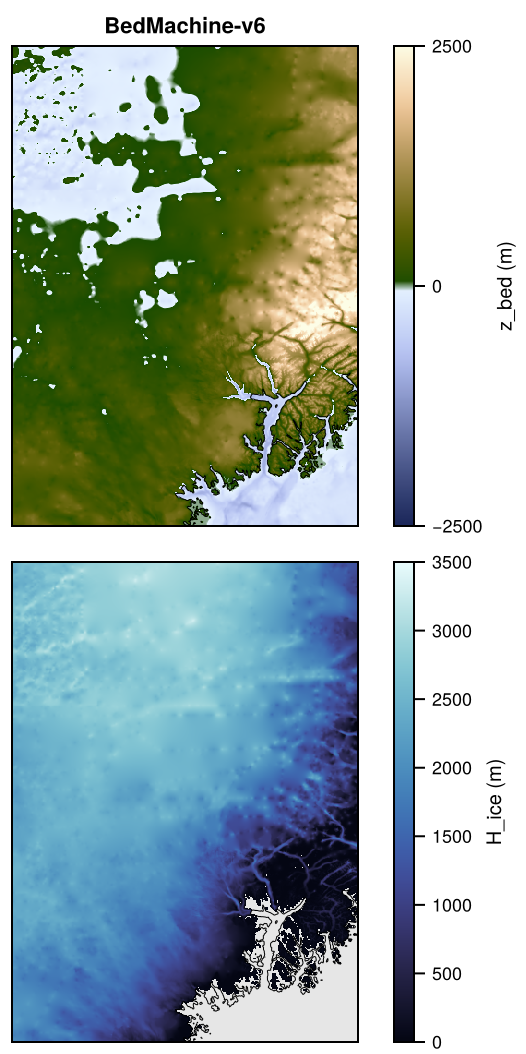
Topo of GreenlandPaleo on GRL-PAL-4KM: z_bed, H_ice.

Topo of GreenlandPaleo on GRL-PAL-4KM: z_bed, H_ice.

Jakobshavn

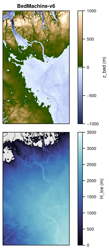
Topo of Jakobshavn on JAK-1KM: z_bed, H_ice.

Topo of Jakobshavn on JAK-1KM: z_bed, H_ice.

NEGIS

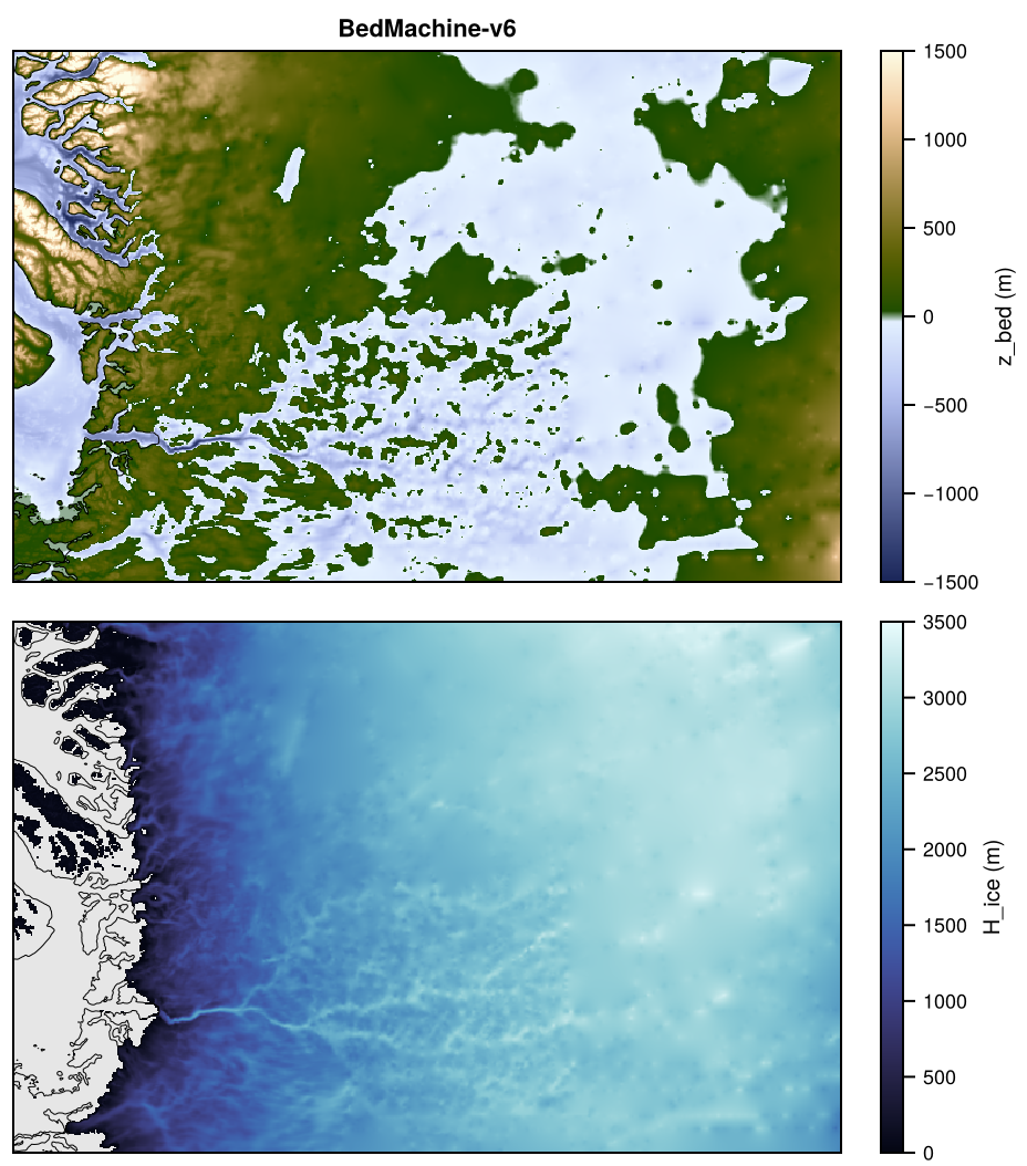
Topo of NEGIS on NEGIS-1KM: z_bed, H_ice.

Topo of NEGIS on NEGIS-1KM: z_bed, H_ice.

Petermann

Topo of Petermann on PET-1KM: z_bed, H_ice.

Topo of Petermann on PET-1KM: z_bed, H_ice.

Helheim

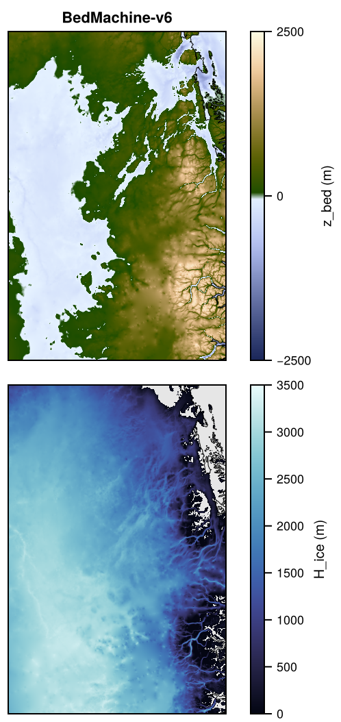
Topo of Helheim on HEL-1KM: z_bed, H_ice.

Topo of Helheim on HEL-1KM: z_bed, H_ice.

North

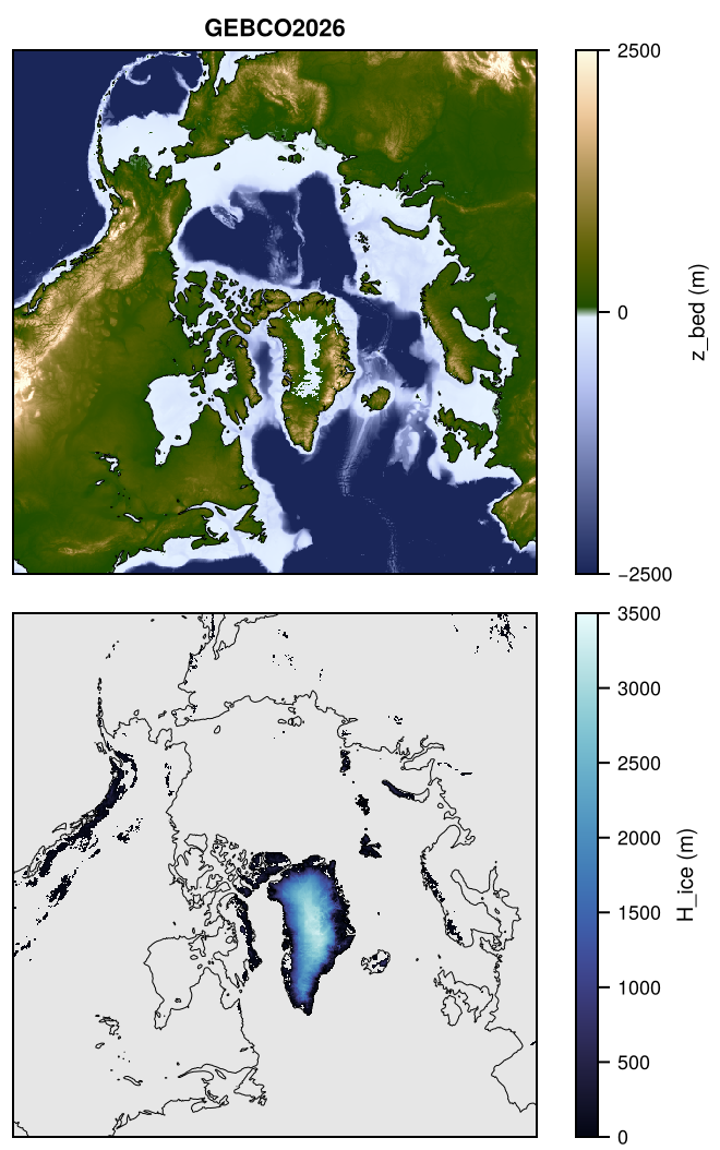
Topo of North on NH-16KM: z_bed, H_ice.

Topo of North on NH-16KM: z_bed, H_ice.

Pyrenees

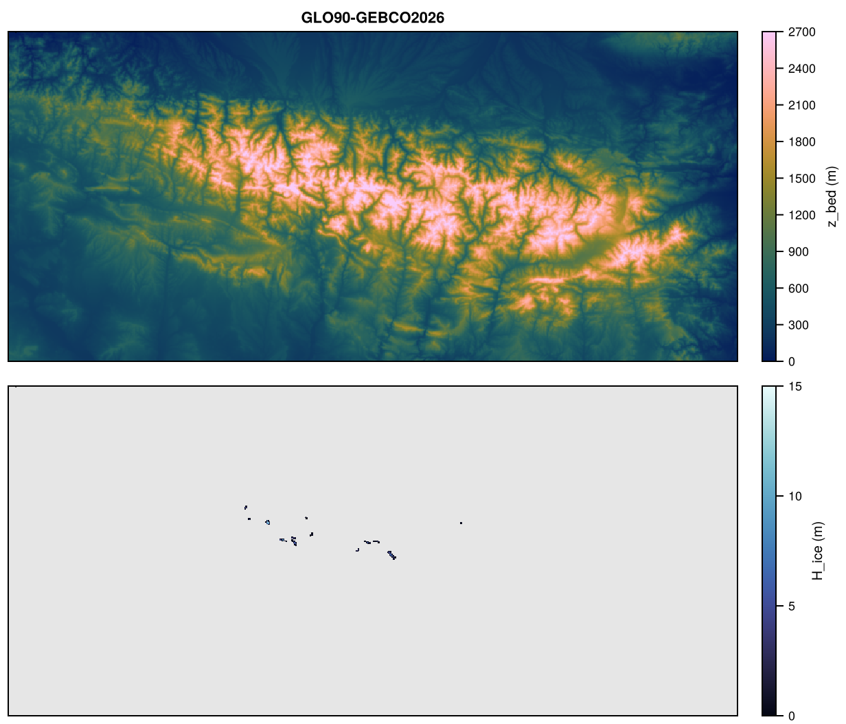
Topo of Pyrenees on PYR-500M: z_bed, H_ice.

Topo of Pyrenees on PYR-500M: z_bed, H_ice.

Alps

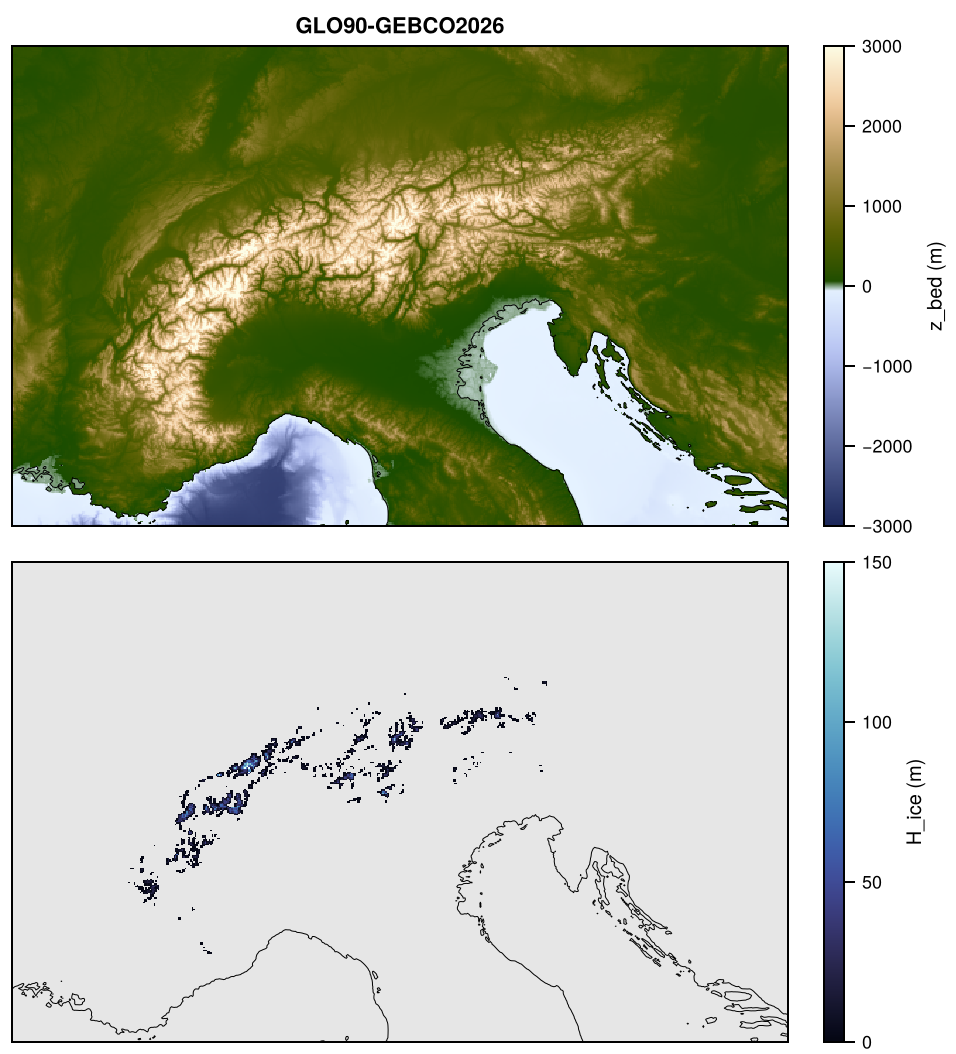
Topo of Alps on ALP-2KM: z_bed, H_ice.

Topo of Alps on ALP-2KM: z_bed, H_ice.

Patagonia

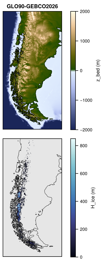
Topo of Patagonia on PAT-2KM: z_bed, H_ice.

Topo of Patagonia on PAT-2KM: z_bed, H_ice.

SRG

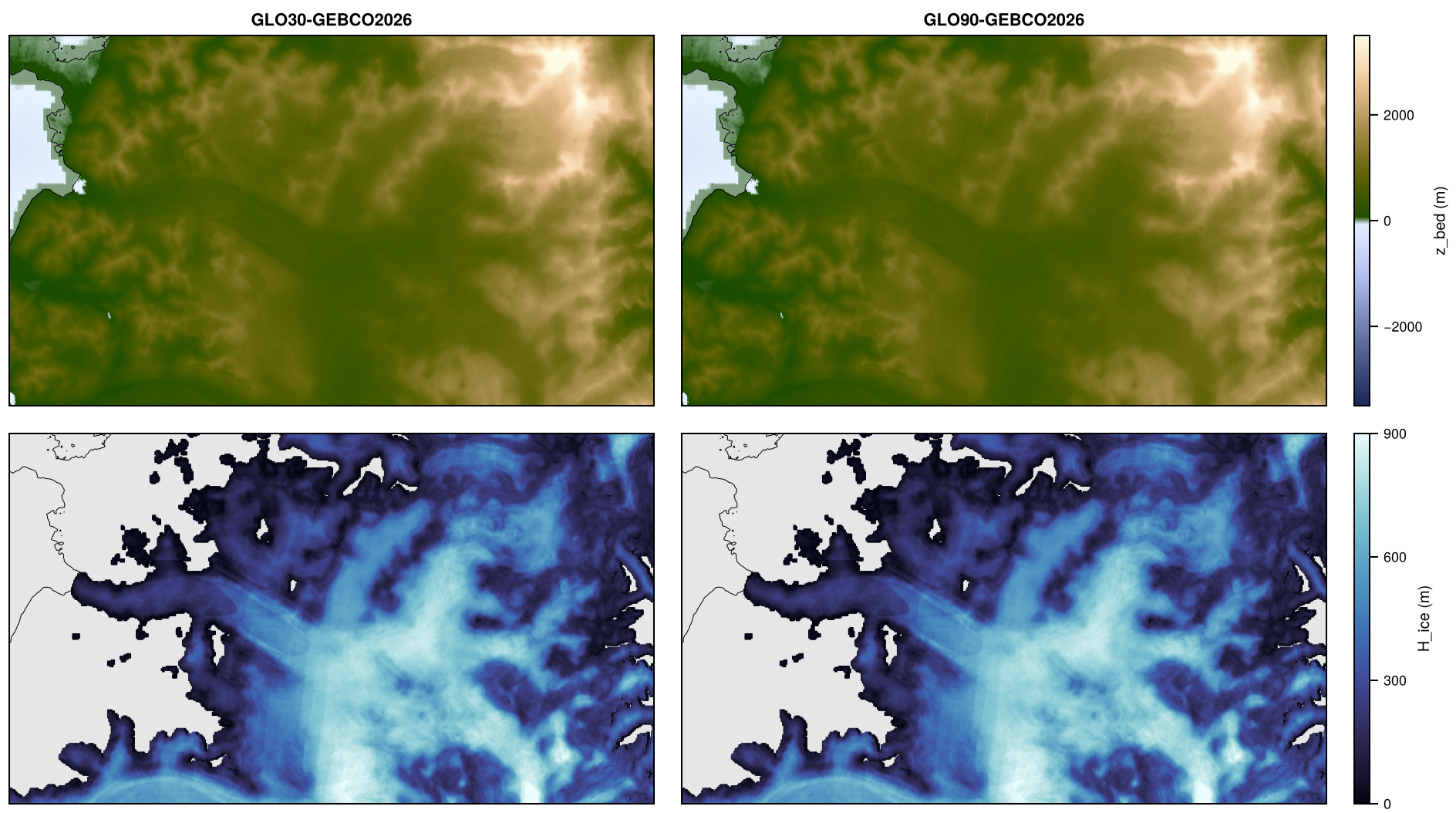
Topo of SRG on SRG-100M: z_bed, H_ice.

Topo of SRG on SRG-100M: z_bed, H_ice.

GranCampoNevado

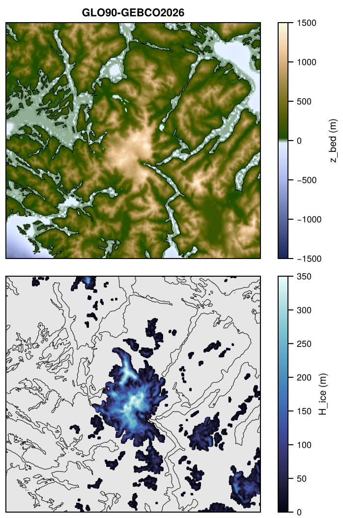
Topo of GranCampoNevado on GCN-100M: z_bed, H_ice.

Topo of GranCampoNevado on GCN-100M: z_bed, H_ice.

CordilleraDarwin

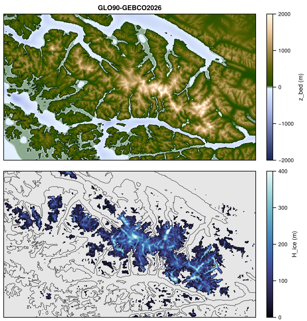
Topo of CordilleraDarwin on CDI-250M: z_bed, H_ice.

Topo of CordilleraDarwin on CDI-250M: z_bed, H_ice.

MonteSarmiento

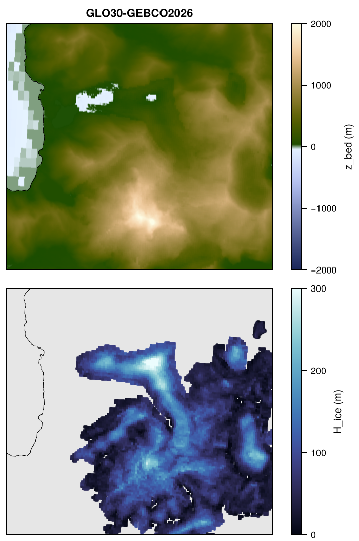
Topo of MonteSarmiento on SAR-50M: z_bed, H_ice.

Topo of MonteSarmiento on SAR-50M: z_bed, H_ice.

SchiaparelliGlacier

Topo of SchiaparelliGlacier on SCH-25M: z_bed, H_ice.

Topo of SchiaparelliGlacier on SCH-25M: z_bed, H_ice.

Himalaya

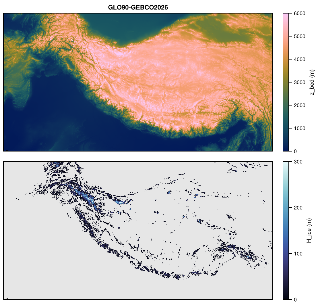
Topo of Himalaya on HIM-2KM: z_bed, H_ice.

Topo of Himalaya on HIM-2KM: z_bed, H_ice.

DrangDrung

Topo of DrangDrung on DDG-50M: z_bed, H_ice.

Topo of DrangDrung on DDG-50M: z_bed, H_ice.

Svalbard

Topo of Svalbard on SVB-2KM: z_bed, H_ice.

Topo of Svalbard on SVB-2KM: z_bed, H_ice.

NewZealand

Topo of NewZealand on NZ-2KM: z_bed, H_ice.

Topo of NewZealand on NZ-2KM: z_bed, H_ice.

Resolutions

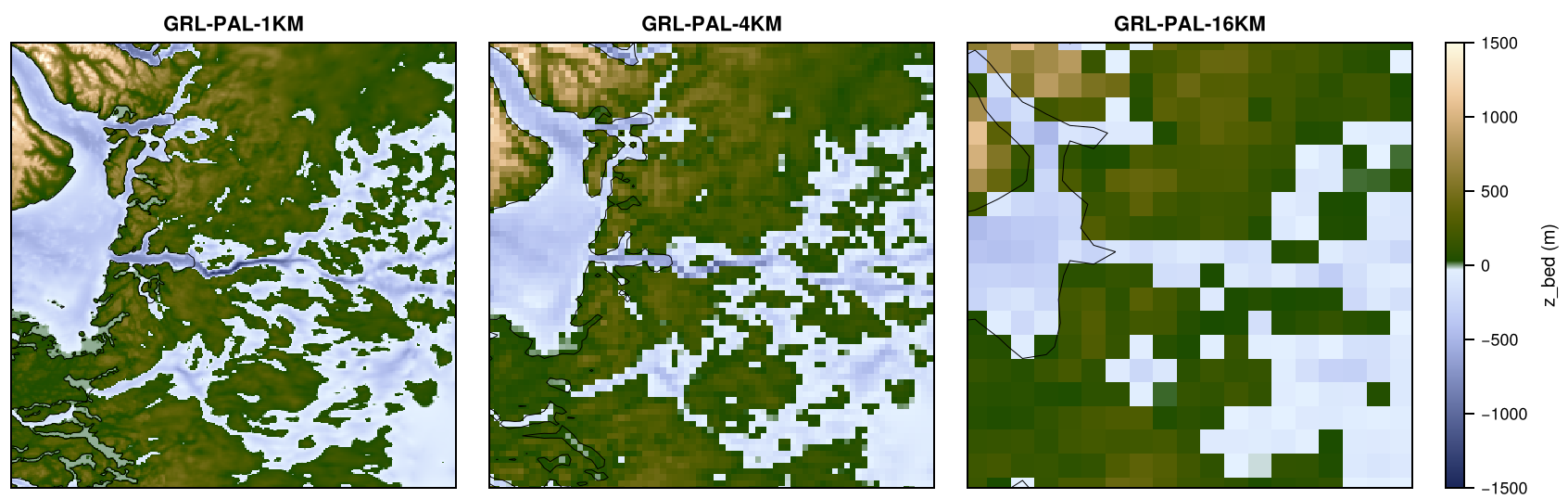
Bed elevation of BedMachine-v6 around Jakobshavn Isbræ (300 km × 300 km) on GRL-PAL-1KM, GRL-PAL-4KM, GRL-PAL-16KM.

Bed elevation of BedMachine-v6 around Jakobshavn Isbræ (300 km × 300 km) on GRL-PAL-1KM, GRL-PAL-4KM, GRL-PAL-16KM.