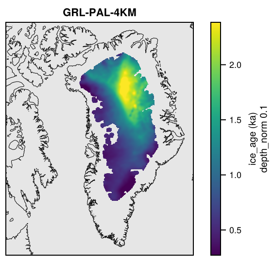
Stratigraphy: age structure of the ice
The age structure of the ice from radar stratigraphy, remapped onto the grids of the domains. Stratigraphy is a thematic dataset made by remapping (see Gridded data): its products are defined in Stratigraphy/remap.toml.
Products
| Product | Source | Fields | Domains |
|---|---|---|---|
Stratigraphy-MacGregor2025 |
MacGregor et al. (2025): RRRAG4 v2, 5 km age structure of the Greenland Ice Sheet from radar stratigraphy 1993-2019, doi:10.5067/SZSVA3CWV3U4 | ice_age, ice_age_sd (ka) on depth_norm (fraction of the ice thickness); depth_iso, depth_iso_sd (m) on age (ka) |
Greenland, GreenlandPaleo |
Each file also has f_valid (with the extra dimension where the coverage differs between levels), the fraction of each cell covered by the source. Fields are remapped conservatively, level by level, and smoothed on grids finer than the source.
Precision
The float fields are rounded on output to a tolerance by kind (see Precision and file sizes): depth_iso and depth_iso_sd to 0.01 m; ice_age and ice_age_sd (ka) to 3 significant digits; f_valid to 0.001.
Licences
| Source | Licence |
|---|---|
| MacGregor et al. (2025), RRRAG4 v2 | CC BY 4.0 (NASA open data, cite the data set) |
Making the dataset
julia -t 8 fesmdata.jl remap StratigraphyDownloads
Download the files with fesmdata.jl into $FESMDATA_PRODUCTS/<Domain>/<GRID>/ (see Download), or one by one from the links below. All released datasets are listed under Products.
GreenlandPaleo
Version 2.1.2 (2026-10-16, packages). 4 files, 6.2 MB.
julia fesmdata.jl fetch Stratigraphy GreenlandPaleo     # all grids
julia fesmdata.jl fetch Stratigraphy GRL-PAL-32KM     # one grid
GRL-PAL-4KM 1 files, 4.3 MB
| GRL-PAL-4KM_Stratigraphy-MacGregor2025.nc | 4.3 MB |
GRL-PAL-8KM 1 files, 1.3 MB
| GRL-PAL-8KM_Stratigraphy-MacGregor2025.nc | 1.3 MB |
GRL-PAL-16KM 1 files, 449.4 kB
| GRL-PAL-16KM_Stratigraphy-MacGregor2025.nc | 449.4 kB |
GRL-PAL-32KM 1 files, 183.7 kB
| GRL-PAL-32KM_Stratigraphy-MacGregor2025.nc | 183.7 kB |
Nests and crops
These nests and crops get products of Stratigraphy by cropping those of the domain (or crop) that contains them: fetch downloads these and cuts them (see Nests and crops), e.g. julia fesmdata.jl fetch Stratigraphy Greenland.
| Nest or crop | Cut from | Products |
|---|---|---|
| Greenland | GreenlandPaleo | 1 |
| Helheim | GreenlandPaleo | 1 |
| Jakobshavn | GreenlandPaleo | 1 |
| NEGIS | GreenlandPaleo | 1 |
| Petermann | GreenlandPaleo | 1 |
Figures
MacGregor2025