IceChange: observed recent change of the ice sheets
Observed recent change of the Antarctic and Greenland ice sheets, remapped onto the grids of the domains: for now, rates of surface elevation change and ice thickness change from satellite laser altimetry; later possibly mass change, and changes of the grounding line and the ice front. IceChange is a thematic dataset made by remapping (see Gridded data): its products are defined in IceChange/remap.toml. Each source has a product per ice sheet (-ANT, -GRL), on the grids of 4 km and coarser.
Products
| Product | Source | Fields | Domains |
|---|---|---|---|
IceChange-ATL15-ANT |
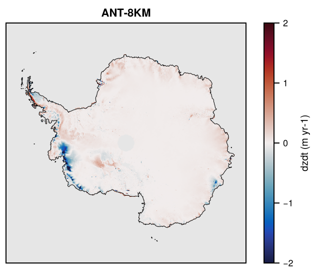
ICESat-2 ATL15 v6 (Smith et al., 2026): linear trend of the quarterly 1 km height change, 2019 to 2026 (cycles 03-31), doi:10.5067/ATLAS/ATL15.006 | dzdt (surface elevation change rate, m yr-1) |
Antarctica |
IceChange-ATL15-GRL |
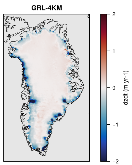
as above, Greenland and its peripheral ice caps | dzdt |
Greenland |
IceChange-Smith2020-ANT |
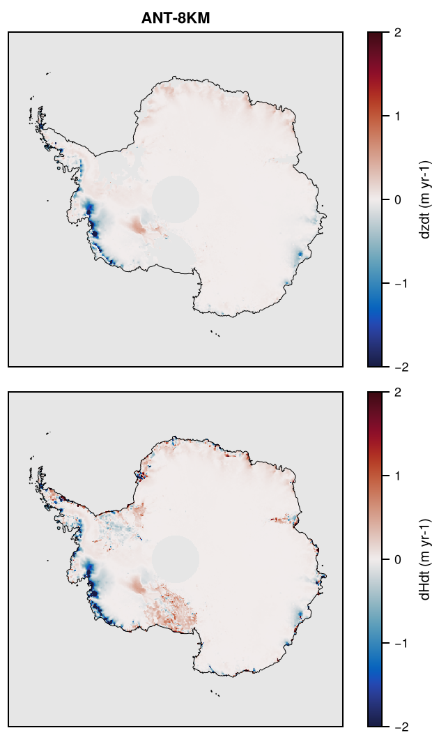
Smith et al. (2020): ICESat (2003-2009) to ICESat-2 (2018-2019), 5 km, grounded and floating ice, doi:10.1126/science.aaz5845, data http://hdl.handle.net/1773/45388 | dzdt (surface elevation change rate of the grounded ice), dHdt (ice thickness change rate, ice equivalent, grounded and floating ice), m yr-1 |
Antarctica |
IceChange-Smith2020-GRL |
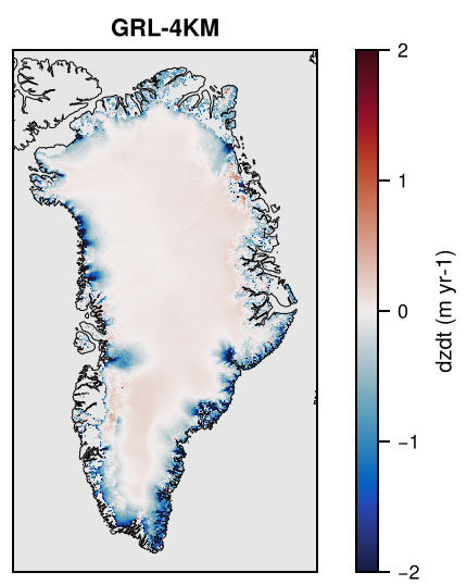
as above, Greenland ice sheet (grounded ice) | dzdt |
Greenland |
dzdt is the rate of change of the surface elevation, including the changes of the firn. dHdt is the rate of change of the ice thickness in ice equivalent: the surface elevation change corrected for changes in firn air content and, over floating ice, converted from elevation change by hydrostatic equilibrium.
ATL15 gives the height change of each quarter relative to 2020 (and rates over moving windows of up to 7 years); dzdt is the linear trend over the whole record in each 1 km cell, the unweighted least-squares fit over the quarters with data and ice in the cell, and missing where fewer than 75% of the quarters have them (e.g. moving ice fronts). The period and the number of quarters are in the global attributes of the files (2019-01-01 to 2026-04-02, 30 quarters, at least 23 valid). The trend agrees with the 7-year rates of ATL15 (dhdt_084mo; correlation 0.92-0.99 by quadrant). Integrated over the ice, dzdt is +107 km3 yr-1 in Antarctica (grounded and floating ice; East Antarctica rising, West Antarctica falling) and -206 km3 yr-1 in Greenland with its peripheral ice caps. There are no data south of about 88°S. See ATL15_dzdt.
Smith et al. (2020) give over floating ice only thickness changes, so dzdt of IceChange-Smith2020-ANT covers the grounded ice only, and dHdt both the grounded and the floating ice, which are on 5 km grids of their own in the source and are combined on each grid (see Several files): where a cell has both, their contributions add up, so that the totals of both are kept. Greenland has no dHdt, as Smith et al. (2020) have no firn correction there. There are no data south of about 86°S (not covered by ICESat). Integrated over the ice, the surface elevation change of the grounded ice of Antarctica is -130 km3 yr-1, its thickness change -127 km3 yr-1 (-116 Gt yr-1 of ice; Smith et al., 2020: -118 Gt yr-1) and that of the floating ice +16 km3 yr-1; the surface elevation change of Greenland is -250 km3 yr-1. See Smith2020_dzdt.
Each file also has f_valid, the fraction of each cell covered by the source (f_valid_<field> where the fields differ). The fields are remapped conservatively, and smoothed on the grids finer than the source (4 km, for the 5 km grids of Smith et al., 2020).
Precision
The float fields are rounded on output to a tolerance by kind (see Precision and file sizes): dzdt and dHdt to 1%; f_valid to 0.001.
Licences
| Source | Licence |
|---|---|
| ICESat-2 ATL15 v6 | NASA Earth science data (NSIDC), no restrictions on use; cite the data set |
| Smith et al. (2020) | CC BY 3.0 US (UW ResearchWorks); cite the article |
Making the dataset
julia -t 8 fesmdata.jl remap IceChange
julia -t 8 fesmdata.jl remap IceChange Smith2020-ANT Smith2020-GRL   # some products
This prepares the sources not prepared yet (<source>/prepare.jl). ATL15 needs a manual download first (NASA Earthdata login, 13 GB, see ATL15_dzdt), and its preparation reads all of it (about 2 GB of memory per quadrant).
Downloads
Download the files with fesmdata.jl into $FESMDATA_PRODUCTS/<Domain>/<GRID>/ (see Download), or one by one from the links below. All released datasets are listed under Products.
Antarctica
Version 2.1.1 (2026-10-16, packages). 8 files, 4.4 MB.
julia fesmdata.jl fetch IceChange Antarctica     # all grids
julia fesmdata.jl fetch IceChange ANT-32KM     # one grid
ANT-4KM 2 files, 3.0 MB
| ANT-4KM_IceChange-ATL15-ANT.nc | 1.1 MB |
| ANT-4KM_IceChange-Smith2020-ANT.nc | 1.9 MB |
ANT-8KM 2 files, 917.9 kB
| ANT-8KM_IceChange-ATL15-ANT.nc | 324.9 kB |
| ANT-8KM_IceChange-Smith2020-ANT.nc | 593.0 kB |
ANT-16KM 2 files, 320.4 kB
| ANT-16KM_IceChange-ATL15-ANT.nc | 114.6 kB |
| ANT-16KM_IceChange-Smith2020-ANT.nc | 205.7 kB |
ANT-32KM 2 files, 136.8 kB
| ANT-32KM_IceChange-ATL15-ANT.nc | 49.9 kB |
| ANT-32KM_IceChange-Smith2020-ANT.nc | 86.9 kB |
Greenland
Version 2.1.1 (2026-10-16, packages). 8 files, 677.3 kB.
julia fesmdata.jl fetch IceChange Greenland     # all grids
julia fesmdata.jl fetch IceChange GRL-32KM     # one grid
GRL-4KM 2 files, 391.2 kB
| GRL-4KM_IceChange-ATL15-GRL.nc | 217.4 kB |
| GRL-4KM_IceChange-Smith2020-GRL.nc | 173.8 kB |
GRL-8KM 2 files, 152.0 kB
| GRL-8KM_IceChange-ATL15-GRL.nc | 81.3 kB |
| GRL-8KM_IceChange-Smith2020-GRL.nc | 70.7 kB |
GRL-16KM 2 files, 81.0 kB
| GRL-16KM_IceChange-ATL15-GRL.nc | 42.7 kB |
| GRL-16KM_IceChange-Smith2020-GRL.nc | 38.3 kB |
GRL-32KM 2 files, 53.3 kB
| GRL-32KM_IceChange-ATL15-GRL.nc | 27.3 kB |
| GRL-32KM_IceChange-Smith2020-GRL.nc | 26.0 kB |
Nests and crops
These nests and crops get products of IceChange by cropping those of the domain (or crop) that contains them: fetch downloads these and cuts them (see Nests and crops), e.g. julia fesmdata.jl fetch IceChange Amery.
| Nest or crop | Cut from | Products |
|---|---|---|
| Amery | Antarctica | 2 |
| Amundsen | Antarctica | 2 |
| FilchnerRonne | Antarctica | 2 |
| Helheim | Greenland | 2 |
| Jakobshavn | Greenland | 2 |
| NEGIS | Greenland | 2 |
| Petermann | Greenland | 2 |
| PineIsland | Antarctica | 2 |
| Ross | Antarctica | 2 |
| Thwaites | Antarctica | 2 |
| WilkesBasin | Antarctica | 2 |
Figures
ATL15-ANT
ATL15-GRL
Smith2020-ANT
Smith2020-GRL