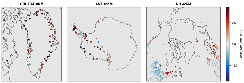
GPS: vertical land motion
Vertical velocities of GPS stations as observational estimates of glacial isostatic adjustment (GIA) uplift rates. GPS is a records dataset (non-gridded data, see Records): its products, defined in GPS/records.toml, are prepared files in the form of the CF discrete sampling geometries, written to $FESMDATA_PRODUCTS/Records/GPS/GPS-<product>.nc.
Products
| Product | Source | Sites | Variables |
|---|---|---|---|
GPS-Schumacher2018 |
Schumacher et al. (2018), doi:10.1594/PANGAEA.889923 | 4072 stations worldwide (54 in the Greenland domain) | uplift_rate, uplift_rate_sd (mm yr-1) |
One value per station (featureType point, dimension station, with lat, lon and site_name): the rates are means over the GPS time series, without a time axis.
Licences
| Source | Licence |
|---|---|
| Schumacher et al. (2018) | CC BY 3.0 (PANGAEA) |
Making the dataset
julia fesmdata.jl record GPSprepares the missing sources (<Source>/prepare.jl), checks the prepared files and copies them to $FESMDATA_PRODUCTS/Records/GPS/ (--overwrite to replace them).
Downloads
Download the files with fesmdata.jl into $FESMDATA_PRODUCTS/<Domain>/<GRID>/ (see Download), or one by one from the links below. All released datasets are listed under Products.
Version 2.1.0 (2026-10-15, packages). 2 files, 583.9 kB.
julia fesmdata.jl fetch GPS Records
GPS 2 files, 583.9 kB
| GPS-Schumacher2018.nc | 338.4 kB |
| GPS-Schumacher2018.txt | 245.5 kB |
Figures
Schumacher2018