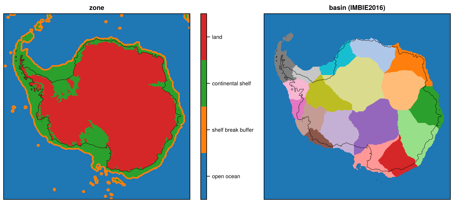
Regions: region masks, zones and basins
Masks of geographic regions, of present-day land, continental shelf and open ocean, and of ice-sheet drainage basins, on every grid of every active domain (see Domains). Regions is made by a pipeline of its own, from the bed elevation of the Topo product of each domain; the Products page shows its versions on each domain.
- Regions are a tree defined once, globally, in
regions.toml, from standard datasets (countries and EEZs, IHO seas, oceans, HydroBASINS, IMBIE basins), so the same region has the same code in every domain. Each level of the tree covers the globe without gaps or overlaps. - Zones separate present-day land, the continental shelf (up to the shelf break) and the open ocean, from the bed elevation of the topography product.
- Basins (
basins.toml) are the drainage basins of the ice sheets, extended over the land and shelf of their region up to the shelf break. - Domains are masks of the nests and crops of a domain on all grids of its family.
Products
| Product | Source | Fields | Domains |
|---|---|---|---|
REGIONS |
Marine Regions (EEZ-land union, IHO Sea Areas, Global Oceans and Seas), HydroBASINS, IMBIE basins (NSIDC-0709); the bed elevation of Topo | region_1, region_2, region_3 (region codes), zone (0-3), dist_shelfbreak (km) |
All |
BASINS-Mouginot2019 |
Greenland glacier basins, 260 basins in 7 regions (Mouginot & Rignot, 2019, doi:10.7280/D1WT11) | basin, basin_mask, basin_group |
GreenlandPaleo, North, with their crops and nests |
BASINS-Zwally2012 |
GSFC drainage systems (Zwally et al., 2012); Greenland sub-systems 11 = 1.1 | basin, basin_mask, basin_group |
GreenlandPaleo, North, Antarctica, with their crops and nests |
BASINS-IMBIE2016, BASINS-IMBIE2016-refined |
IMBIE 2016 and refined basins (Mouginot et al., 2017, NSIDC-0709 v2, doi:10.5067/AXE4121732AD) | basin, basin_mask, basin_group |
Antarctica, with its crops and nests |
BASINS-Schmidt2025 |
Regions of the freshwater fluxes of the ice sheets (Schmidt et al., 2025, doi:10.5281/zenodo.17386710): 7 Mouginot regions of Greenland, 18 IMBIE 2016 basins of Antarctica | basin, basin_mask, basin_group |
GreenlandPaleo, North, Antarctica, with their crops and nests |
BASINS-SanRafael |
San Rafael Glacier (RGI2000-v7.0-G-17-12835), its RGI 7.0 outline as the footprint of its IceBoost v2 tile | basin, basin_mask |
SRG |
BASINS-NEGIS-v1 |
Northeast Greenland Ice Stream in three parts, drawn by hand for yelmox v1 on GRL-16KM (Ilaria Tabone, 2024) | basin, basin_mask |
GreenlandPaleo, Greenland, NEGIS |
BASINS-NEGIS |
Northeast Greenland Ice Stream in three parts: centre and south from the surface speed (Joughin et al., 2018), north from NEGIS-v1 | basin, basin_mask |
GreenlandPaleo, Greenland, NEGIS |
DOMAINS |
Extents of the nests and crops (../shared/domains.toml) |
domain_<KEY> (0/1), one per nest and crop |
Domains with nests or crops, with their crops and nests |
The files are <GRID>_REGIONS.nc, <GRID>_BASINS-<set>.nc and <GRID>_DOMAINS.nc. Regions, zones and basins are computed on the base grid of a domain (e.g. ANT-500M, GRL-PAL-500M, NH-2KM, PAT-250M, SRG-50M) and then mapped onto all other grids and crops, as for the topography; a nest (e.g. SRG in PAT) is computed on its own base grid. On each other grid, region codes, zones and basins are the class covering most of a cell, nested level by level (a cell’s region_3 lies within its region_2; basins within their group), and dist_shelfbreak is the cell mean.
Region codes
A region is named by its path in the tree: “1.3.1” is subregion 1 of region 3 of region 1. Its code is the integer with two digits per level below the first: “1” = 1, “1.3” = 103, “1.3.1” = 10301. The files have one variable per level, region_1, region_2, region_3, each with the code of the deepest region at or above that level, so a cell without a subregion keeps the code of its region. The names of the codes are in the attributes flag_values and flag_meanings. Codes of ocean regions start at 51. Helpers for codes are in FesmUtils.jl (region_code, region_path, region_ancestor, in_region).
| Level 2 | Level 3 |
|---|---|
| 1.1 North America | 1.1.1 Canadian Arctic Archipelago, 1.1.2 Hudson Bay and Strait, 1.1.3 Cordillera and Alaska |
| 1.2 Western Eurasia | 1.2.1 Barents-Kara, 1.2.2 British Isles, 1.2.3 Svalbard, 1.2.4 Fennoscandia |
| 1.3 Greenland, 1.4 Asia, 1.5 Iceland, 1.6 Africa, 1.7 Latin America and the Caribbean, 1.8 Oceania | |
| 1.51 Arctic Ocean, 1.52 North Atlantic Ocean (with Baltic and Mediterranean), 1.53 North Pacific Ocean, 1.54 Indian Ocean, 1.55 South China and Eastern Archipelagic Seas | |
| 2.1 Antarctica (south of 60S) | 2.1.1 West Antarctica, 2.1.2 East Antarctica, 2.1.3 Antarctic Peninsula |
| 2.2 Latin America and the Caribbean, 2.3 Africa, 2.4 Asia, 2.5 Oceania, 2.51 South Atlantic, 2.52 South Pacific, 2.53 Indian Ocean, 2.54 South China and Eastern Archipelagic Seas |
The rules of each region are documented in regions.toml. In short:
- Continents are the countries and their EEZs grouped by UN M49 region; Greenland and Iceland come first; oceans (GOaS) take the rest. The high seas of the Davis Strait, which GOaS puts in the Arctic Ocean, are in the North Atlantic, with the rest of the high seas of the Labrador Sea. The high seas of the Norwegian and Greenland seas, a pocket enclosed by the EEZs of Norway, the Faroe Islands, Iceland and Greenland that GOaS also puts in the Arctic Ocean, are in Western Eurasia.
- Russia is split between Western Eurasia and Asia at the divide between the rivers draining to the Kara and Laptev seas (HydroBASINS), and at sea at the boundary between the Kara and Laptev seas (IHO). Its EEZ in the Baltic and Black seas is in Western Eurasia.
- The NA subregions follow HydroBASINS and IHO seas; Hudson Bay and Strait include only the coastal basins draining into them, not the large rivers, and all their islands. Cordillera and Alaska includes the EEZs of North America in the Pacific.
- The Antarctic subregions are the IMBIE regions, extended to fill all of 2.1.
- Cells of a region enclosed by its subregions but covered by none of them (where the coastlines of the sources do not match) get the nearest subregion.
The mountain-glacier domains lie within few regions of level 2: e.g. PYR in 1.2 Western Eurasia (land and EEZs of Spain, France and Andorra) and 1.52 North Atlantic Ocean (beyond the EEZs, if any), PAT and its nests in 2.2 Latin America and the Caribbean.
Zones
zone is 3 for present-day land (ice-free land and grounded ice), 2 for the continental shelf (including floating ice), 1 for open ocean within buffer (50 km) of the shelf break, and 0 for the open ocean beyond. dist_shelfbreak (km) is the distance to the shelf break, positive in the open ocean, so other buffers are a threshold on it.
The open ocean is the ice-free ocean connected to the abyss (deeper than z_abyss = -2000 m) through cells deeper than the shelf-break depth z_break (-500 m, -1000 m around Antarctica), after removing channels narrower than about 100 km (an opening of radius r_open = 50 km), which also smooths the shelf break. Deep troughs on the shelf that deepen towards the ice sheet are therefore shelf. The parameters are in regions.toml.
A domain without open ocean, where no ocean deeper than z_abyss lies within the domain (e.g. the mountain-glacier domains PYR and SRG), has only land and shelf, and dist_shelfbreak is -Inf everywhere (as noted in the comment attribute of the variable).
Basins
Each file has basin, basin_mask (1 within the original basins) and, for sets with groups (e.g. Mouginot regions, IMBIE regions, Zwally systems), basin_group. The islands in the ice shelves of IMBIE2016-refined keep their extent but are not extended, so the ice shelves around them go to the neighbouring grounded basins.
SanRafael is a single basin (1), the cells at least half covered by the glacier, not extended: the part of the SRG domain that evolves freely in yelmox, while the rest relaxes to the present-day state (in v1, regions = 1 of SRG-250M_REGIONS.nc). PYR has no basins.
Schmidt2025
The regions to which the freshwater fluxes of the ice sheets are attributed in the protocol of Schmidt et al. (2025) (GL_regions_3413.gpkg, AQ_regions_3031.gpkg of Zenodo record 17386710), so that their time series (see Schmidt2025_fwf) can be mapped onto the grids. basin is the region number of the time series (names in alphabetical order): Greenland 1-7 = CE, CW, NE, NO, NW, SE, SW; Antarctica 1-18 = A-Ap, Ap-B, …, K-A, grouped in basin_group by IMBIE region (East, Peninsula, West).
The polygons cover the ice sheets only (and not the ocean). In Greenland they are the Mouginot (2019) regions without their peripheral ice caps (ICE_CAPS_*, 59 000 km2), which go to the nearest region in the extension: the set is the same region as the groups of Mouginot2019 on 99.99% of the cells of the polygons and 98% after the extension. In Antarctica they are the IMBIE 2016 basins of NSIDC-0709 v2 (identical geometry), so the set is identical to IMBIE2016.
The basins are extended as the other sets (over land and shelf up to the shelf break), not as in the *_regions_*_flood.nc files of the record: these are the regions grown over the whole rectangle around the ice sheet at 1 km (GRASS r.grow, nearest region in straight line, over the open ocean and other land), and the Antarctic one is numbered in another order than the time series (A-Ap = 7, Ap-B = 11, …).
NEGIS
The NEGIS sets split the Northeast Greenland Ice Stream into three parts, to tune basal friction by part in yelmox: basin 1 centre (the trunk of 79N and Zachariae Isstrom down to the coast), 2 south (the trunk upstream), 3 north (the northern arm), 0 outside. They are not extended, so basin_mask is basin != 0, and have no groups (negis.jl).
NEGIS-v1 are the parts of yelmox v1 (basin_sub 9.1, 9.2, 9.3 of GRL-16KM_BASINS-nasa-negis-three.nc), drawn by hand by Ilaria Tabone (2024) on GRL-16KM. They cannot be rebuilt, so the 248 cells are kept in the repository (sources/negis_v1_GRL-16KM.csv). Each cell of the base grid takes the part of the GRL-16KM cell containing its centre, so GRL-16KM reproduces v1 exactly (checked by 06_negis.jl, 0 cells differ), and the other grids are the majority as for all basins.
NEGIS builds the centre and south parts from the present-day surface speed, the cell mean of the 250 m MEaSUREs velocity mosaic (NSIDC-0670 v1; Joughin et al., 2018) on the base grid. The stream is the cells of Zwally drainage system 2 with grounded ice (the topography of the zones) and a speed of at least 50 m/yr (30 m/yr south of the cut), connected to the cell nearest to (400, -1162) km in the trunk of 79N. This leaves out the separate fast cells of Storstrommen and L. Bistrup Brae. South is the stream south of the cut line y = -1140 - 0.3 x (km, GRL polar stereographic), centre the rest. The north part of v1 follows a palaeo ice stream that shut down in the Holocene (Franke et al., 2022) and is slow today (4-50 m/yr), so neither a lower speed threshold nor a band along the present flow reproduces it (IoU of the north part 0.50 and 0.73 at best). Franke et al. publish only the radar data (PANGAEA), not an outline, so the north part is that of NEGIS-v1, and replaces the others where they overlap. The parameters are in basins.toml ([basins.negis]).
The parameters give the best match of the v1 parts on GRL-16KM, among cut lines, thresholds of the south part of 20-50 m/yr, and other splits (06_negis.jl):
| Part | Cells | v1 cells | IoU |
|---|---|---|---|
| centre | 82 | 94 | 0.80 |
| south | 101 | 96 | 0.86 |
| north | 58 | 58 | 1.00 |
| all | 241 | 248 | 0.90 |
The whole stream at 50 m/yr matches the single v1 NEGIS basin (basin 9 of GRL-16KM_BASINS-nasa-negis.nc) with IoU 0.88. The v1 centre also has a few isolated cells near Storstrommen, left out here. A cut at a surface elevation of 1450 m instead of the line gives IoU 0.74 (centre) and 0.79 (south), and a cut at a distance along the stream from the grounding line of 79N (200 km) 0.68 and 0.63. The Mouginot basins of 79N, Zachariae Isstrom and Storstrommen are far broader than the stream (IoU 0.23).
Domains
<GRID>_DOMAINS.nc locates the nests and crops of a domain family (a domain with all its nests and crops) on every grid of the family, e.g. NPI, SPI, SRG, GCN, CDI, SAR and SCH on the grids of PAT, of its crops and of its nests. domain_<KEY> (int8) is 1 where the cell centre lies within the extent of nest or crop KEY, the cell edges of its base grid (that of its domain for a crop), and 0 elsewhere; one variable per nest or crop, as they may overlap (SRG lies in NPI). Its attributes give the folder (long_name), kind (nest or crop), parent (key) and extent (x0, x1, y0, y1, km). Only active nests and crops are included, and domains without any (e.g. PYR) have no file. The masks are computed on each grid from the cell centres (07_domains.jl).
Precision
Region codes, zones and basins are integers and exact. dist_shelfbreak (km) is rounded on output to 3 significant digits (see Precision and file sizes); the intermediate files on the base grid (steps 1-3) are not rounded.
Sources and licences
| Source | Licence |
|---|---|
| Marine Regions: EEZ-land union v4, IHO Sea Areas v3, Global Oceans and Seas v1 (Flanders Marine Institute) | CC BY 4.0 |
| HydroBASINS v1c (Lehner and Grill, 2013) | HydroSHEDS licence: free use with attribution |
| ISO 3166 countries with UN M49 regions | CC BY-SA 4.0 (the repository; used only to group the territories by continent) |
| Mouginot and Rignot (2019), Dryad | CC0 1.0 (Dryad) |
| NSIDC-0709 v2 (Mouginot et al., 2017) and NSIDC-0670 v1 (Joughin et al., 2018) | NASA NSIDC DAAC: no restrictions on use (cite the data) |
| Zwally et al. (2012) | No licence stated (GSFC web page) |
| Schmidt et al. (2025), Zenodo | CC BY 4.0 |
| NEGIS-v1 (Ilaria Tabone, 2024) | Kept in the repository (sources/negis_v1_GRL-16KM.csv) |
References:
- Franke, S., Bons, P. D., Westhoff, J., et al. (2022). Holocene ice-stream shutdown and drainage basin reconfiguration in northeast Greenland. Nature Geoscience, 15, 995-1001. doi:10.1038/s41561-022-01082-2
- Flanders Marine Institute (2024). Union of the ESRI Country shapefile and the Exclusive Economic Zones (version 4). doi:10.14284/698
- Flanders Marine Institute (2018). IHO Sea Areas, version 3. doi:10.14284/323
- Flanders Marine Institute (2021). Global Oceans and Seas, version 1. doi:10.14284/542
- Joughin, I., Smith, B. E. and Howat, I. M. (2018). A complete map of Greenland ice velocity derived from satellite data collected over 20 years. Journal of Glaciology, 64(243), 1-11. doi:10.1017/jog.2017.73 (MEaSUREs Multi-year Greenland Ice Sheet Velocity Mosaic, Version 1, NSIDC-0670, doi:10.5067/QUA5Q9SVMSJG)
- Lehner, B. and Grill, G. (2013). Global river hydrography and network routing: baseline data and new approaches to study the world’s large river systems. Hydrological Processes, 27(15), 2171-2186 (HydroBASINS v1c).
- ISO 3166 countries with UN M49 regions: github.com/lukes/ISO-3166-Countries-with-Regional-Codes
- Mouginot, J. and Rignot, E. (2019). Glacier catchments/basins for the Greenland Ice Sheet. Dryad. doi:10.7280/D1WT11
- Mouginot, J., Scheuchl, B. and Rignot, E. (2017). MEaSUREs Antarctic Boundaries for IPY 2007-2009 from Satellite Radar, Version 2. NSIDC. doi:10.5067/AXE4121732AD
- Schmidt, G. A., Mankoff, K. D., Bamber, J. L., et al. (2025). Datasets and protocols for including anomalous freshwater from melting ice sheets in climate simulations. Geoscientific Model Development, 18, 8333-8361. doi:10.5194/gmd-18-8333-2025 (data: doi:10.5281/zenodo.17386710)
- Zwally, H. J., Giovinetto, M. B., Beckley, M. A. and Saba, J. L. (2012). Antarctic and Greenland Drainage Systems. GSFC Cryospheric Sciences Laboratory.
Making the dataset
The machine environment is set up as described under Machines and storage.
Layout
| Location | Contents |
|---|---|
$FESMDATA_SOURCES |
Original datasets (see ../datamanifest.toml) |
$FESMDATA_PRODUCTS/<Domain>/<GRID>/ |
Output: <GRID>_REGIONS.nc, <GRID>_BASINS-<set>.nc, <GRID>_DOMAINS.nc |
$FESMDATA_WORK/regions/ |
Intermediate files (base grids) and check plots |
Steps
All commands are run from the FesmData root after sourcing the machine environment. Each step can be submitted as a job on a Levante compute node:
sbatch --job-name=<name> Regions/jobs/run_step.sbatch <script> <args...>and Regions/jobs/submit_domain.sh DOMAIN [FIRST_STEP] submits steps 1-5 as a chain of jobs, and step 7. The topography product of the domain (Topo, step 3) is needed from step 2.
0. Original datasets
The datasets are listed and downloaded with the Topo script (on a login node):
julia --project=Topo Topo/scripts/00_sources.jl --downloadThe Marine Regions layers (EEZ-land union v4, IHO Sea Areas v3, GOaS v1) are fetched from its WFS server, HydroBASINS, the Zwally drainage systems and the ISO 3166/M49 table directly. Two need a manual download into the folder printed by the script:
- Mouginot & Rignot (2019) basins: the
Greenland_Basins_PS_v1.4.2.*files from Dryad. - NSIDC-0709 v2 (NASA Earthdata login, see Topo): the
.shp,.shx,.dbfand.prjfiles ofBasins_IMBIE_Antarctica_v02andBasins_Antarctica_v02, from theuriin../datamanifest.toml. - NSIDC-0670 v1 (NASA Earthdata login):
greenland_vel_mosaic250_vx_v1.tifandgreenland_vel_mosaic250_vy_v1.tif(NEGIS), from theuriin../datamanifest.toml.
1. Regions
sbatch --job-name=regions-NH Regions/jobs/run_step.sbatch 01_regions.jl NHWrites region_1-region_3 on the base grid. The job log lists the cells of each region, and the cells that were filled with the nearest region.
2. Zones
sbatch --job-name=zone-NH Regions/jobs/run_step.sbatch 02_zone.jl NH3. Basins
sbatch --job-name=basins-ANT Regions/jobs/run_step.sbatch 03_basins.jl ANT [SET]NEGIS reads the grounded ice of the topography of the zones (step 2).
4. All grids
sbatch --job-name=grids-all-NH Regions/jobs/run_step.sbatch 04_grids.jl NH [SET]With SET, only the files of that basin set are written.
5. Checks
sbatch --job-name=plots-NH Regions/jobs/run_step.sbatch 05_plots.jl NH [GRID]Writes maps of the regions, zones and basins to $FESMDATA_WORK/regions/plots/.
The NEGIS sets are checked against v1 on GRL-16KM (cells and IoU of each part, and a map, $FESMDATA_WORK/regions/plots/GRL-16KM_negis.png):
sbatch --job-name=negis Regions/jobs/run_step.sbatch 06_negis.jl \
    /work/ba1442/ice_data/Greenland/GRL-16KM/GRL-16KM_BASINS-nasa-negis-three.nc
The v1 file is optional; with it, the script checks that NEGIS-v1 reproduces it.
7. Domains
sbatch --job-name=domains-PAT Regions/jobs/run_step.sbatch 07_domains.jl PATWrites <GRID>_DOMAINS.nc on all grids of the domain and its crops (run it for each domain and nest of a family). Needs no other step; rerun it for the whole family when a nest or crop is added or changed.
Adding a region, a basin set or a domain
A region is an entry of regions.toml, with its path, name and rules:
[[region]]
path = "1.2.3"
name = "Svalbard"
rules = [{ source = "eez_land", field = "territory1", values = ["Svalbard"] }]
A region covers the union of its rules, within its parent; siblings are applied in the order of the file, so a cell taken by an earlier sibling stays with it. Cells of a region that none of its subregions covers keep the code of the region, unless its subregions enclose them. A rule selects features of a polygon source (eez_land, iho, goas, hydrobasins, imbie) by the values of a field, or a lon/lat box, and can be limited within or without other rules (see the header of regions.toml). A region with fill = true gives its cells outside all its subregions to the nearest subregion. Ocean regions are numbered from 51. Changing the tree changes the codes of all domains, so it is a new release of Regions; then run steps 1 and 4 (and 5) for every domain.
A basin set is an entry of basins.toml: its name, domains, the region it is extended in (up to the shelf break), its polygon source, and the attribute identifying the basins (id_field), optionally a grouping (group_field), selected features, or basins that are not extended (no_extension); see the header of basins.toml. Then run steps 3-5 for its domains (03_basins.jl <DOMAIN> <SET>, 04_grids.jl <DOMAIN> <SET>). Its files are released with the next release of Regions.
A polygon source is an entry of ../datamanifest.toml (with its DOI), a branch in _read_source and in manifest_keys in sources.jl (the polygons in lon/lat as Shapes, with their attributes).
A domain: define it in ../shared/domains.toml (see Overview and code), make its topography (Topo), and add the topography product of its zones to [zone] products in regions.toml (and its shelf-break depth z_break if its region needs another one). Add it to the domains of its basin sets, if any, and run all steps (jobs/submit_domain.sh <DOMAIN>). The region tree is global, so a new domain needs no new regions.
Downloads
Download the files with fesmdata.jl into $FESMDATA_PRODUCTS/<Domain>/<GRID>/ (see Download), or one by one from the links below. All released datasets are listed under Products.
Antarctica
Version 2.6.1 (2026-10-16, packages). 42 files, 78.9 MB.
julia fesmdata.jl fetch Regions Antarctica     # all grids
julia fesmdata.jl fetch Regions ANT-32KM     # one grid
ANT-500M 6 files, 50.6 MB
| ANT-500M_BASINS-IMBIE2016-refined.nc | 2.8 MB |
| ANT-500M_BASINS-IMBIE2016.nc | 2.4 MB |
| ANT-500M_BASINS-Schmidt2025.nc | 2.4 MB |
| ANT-500M_BASINS-Zwally2012.nc | 1.6 MB |
| ANT-500M_DOMAINS.nc | 1.6 MB |
| ANT-500M_REGIONS.nc | 39.9 MB |
ANT-1KM 6 files, 17.7 MB
| ANT-1KM_BASINS-IMBIE2016-refined.nc | 993.7 kB |
| ANT-1KM_BASINS-IMBIE2016.nc | 804.9 kB |
| ANT-1KM_BASINS-Schmidt2025.nc | 804.9 kB |
| ANT-1KM_BASINS-Zwally2012.nc | 558.5 kB |
| ANT-1KM_DOMAINS.nc | 466.0 kB |
| ANT-1KM_REGIONS.nc | 14.0 MB |
ANT-2KM 6 files, 6.5 MB
| ANT-2KM_BASINS-IMBIE2016-refined.nc | 396.1 kB |
| ANT-2KM_BASINS-IMBIE2016.nc | 319.3 kB |
| ANT-2KM_BASINS-Schmidt2025.nc | 319.3 kB |
| ANT-2KM_BASINS-Zwally2012.nc | 229.8 kB |
| ANT-2KM_DOMAINS.nc | 230.7 kB |
| ANT-2KM_REGIONS.nc | 5.1 MB |
ANT-4KM 6 files, 2.4 MB
| ANT-4KM_BASINS-IMBIE2016-refined.nc | 173.2 kB |
| ANT-4KM_BASINS-IMBIE2016.nc | 137.8 kB |
| ANT-4KM_BASINS-Schmidt2025.nc | 137.8 kB |
| ANT-4KM_BASINS-Zwally2012.nc | 103.5 kB |
| ANT-4KM_DOMAINS.nc | 102.9 kB |
| ANT-4KM_REGIONS.nc | 1.8 MB |
ANT-8KM 6 files, 936.1 kB
| ANT-8KM_BASINS-IMBIE2016-refined.nc | 79.0 kB |
| ANT-8KM_BASINS-IMBIE2016.nc | 63.7 kB |
| ANT-8KM_BASINS-Schmidt2025.nc | 63.7 kB |
| ANT-8KM_BASINS-Zwally2012.nc | 53.5 kB |
| ANT-8KM_DOMAINS.nc | 72.2 kB |
| ANT-8KM_REGIONS.nc | 604.0 kB |
ANT-16KM 6 files, 446.7 kB
| ANT-16KM_BASINS-IMBIE2016-refined.nc | 48.8 kB |
| ANT-16KM_BASINS-IMBIE2016.nc | 40.9 kB |
| ANT-16KM_BASINS-Schmidt2025.nc | 40.9 kB |
| ANT-16KM_BASINS-Zwally2012.nc | 35.1 kB |
| ANT-16KM_DOMAINS.nc | 60.8 kB |
| ANT-16KM_REGIONS.nc | 220.3 kB |
ANT-32KM 6 files, 271.4 kB
| ANT-32KM_BASINS-IMBIE2016-refined.nc | 35.4 kB |
| ANT-32KM_BASINS-IMBIE2016.nc | 30.7 kB |
| ANT-32KM_BASINS-Schmidt2025.nc | 30.7 kB |
| ANT-32KM_BASINS-Zwally2012.nc | 24.8 kB |
| ANT-32KM_DOMAINS.nc | 55.2 kB |
| ANT-32KM_REGIONS.nc | 94.6 kB |
Amundsen
Version 2.6.1 (2026-10-16, packages). 42 files, 3.5 MB.
julia fesmdata.jl fetch Regions Amundsen     # all grids
julia fesmdata.jl fetch Regions ASE-32KM     # one grid
ASE-500M 6 files, 1.6 MB
| ASE-500M_BASINS-IMBIE2016-refined.nc | 178.9 kB |
| ASE-500M_BASINS-IMBIE2016.nc | 147.6 kB |
| ASE-500M_BASINS-Schmidt2025.nc | 147.6 kB |
| ASE-500M_BASINS-Zwally2012.nc | 115.1 kB |
| ASE-500M_DOMAINS.nc | 129.0 kB |
| ASE-500M_REGIONS.nc | 898.5 kB |
ASE-1KM 6 files, 678.8 kB
| ASE-1KM_BASINS-IMBIE2016-refined.nc | 80.5 kB |
| ASE-1KM_BASINS-IMBIE2016.nc | 67.9 kB |
| ASE-1KM_BASINS-Schmidt2025.nc | 67.9 kB |
| ASE-1KM_BASINS-Zwally2012.nc | 59.1 kB |
| ASE-1KM_DOMAINS.nc | 82.3 kB |
| ASE-1KM_REGIONS.nc | 321.1 kB |
ASE-2KM 6 files, 366.2 kB
| ASE-2KM_BASINS-IMBIE2016-refined.nc | 45.2 kB |
| ASE-2KM_BASINS-IMBIE2016.nc | 42.0 kB |
| ASE-2KM_BASINS-Schmidt2025.nc | 42.0 kB |
| ASE-2KM_BASINS-Zwally2012.nc | 38.8 kB |
| ASE-2KM_DOMAINS.nc | 64.9 kB |
| ASE-2KM_REGIONS.nc | 133.4 kB |
ASE-4KM 6 files, 250.4 kB
| ASE-4KM_BASINS-IMBIE2016-refined.nc | 33.4 kB |
| ASE-4KM_BASINS-IMBIE2016.nc | 31.4 kB |
| ASE-4KM_BASINS-Schmidt2025.nc | 31.3 kB |
| ASE-4KM_BASINS-Zwally2012.nc | 26.1 kB |
| ASE-4KM_DOMAINS.nc | 56.7 kB |
| ASE-4KM_REGIONS.nc | 71.5 kB |
ASE-8KM 6 files, 205.5 kB
| ASE-8KM_BASINS-IMBIE2016-refined.nc | 27.9 kB |
| ASE-8KM_BASINS-IMBIE2016.nc | 26.9 kB |
| ASE-8KM_BASINS-Schmidt2025.nc | 26.9 kB |
| ASE-8KM_BASINS-Zwally2012.nc | 21.9 kB |
| ASE-8KM_DOMAINS.nc | 53.3 kB |
| ASE-8KM_REGIONS.nc | 48.6 kB |
ASE-16KM 6 files, 184.5 kB
| ASE-16KM_BASINS-IMBIE2016-refined.nc | 24.4 kB |
| ASE-16KM_BASINS-IMBIE2016.nc | 24.2 kB |
| ASE-16KM_BASINS-Schmidt2025.nc | 24.2 kB |
| ASE-16KM_BASINS-Zwally2012.nc | 20.6 kB |
| ASE-16KM_DOMAINS.nc | 52.6 kB |
| ASE-16KM_REGIONS.nc | 38.5 kB |
ASE-32KM 6 files, 181.1 kB
| ASE-32KM_BASINS-IMBIE2016-refined.nc | 24.4 kB |
| ASE-32KM_BASINS-IMBIE2016.nc | 24.2 kB |
| ASE-32KM_BASINS-Schmidt2025.nc | 24.2 kB |
| ASE-32KM_BASINS-Zwally2012.nc | 20.6 kB |
| ASE-32KM_DOMAINS.nc | 52.6 kB |
| ASE-32KM_REGIONS.nc | 35.1 kB |
Thwaites
Version 2.6.1 (2026-10-16, packages). 12 files, 1.6 MB.
julia fesmdata.jl fetch Regions Thwaites     # all grids
julia fesmdata.jl fetch Regions THW-1KM     # one grid
THW-500M 6 files, 1.1 MB
| THW-500M_BASINS-IMBIE2016-refined.nc | 119.2 kB |
| THW-500M_BASINS-IMBIE2016.nc | 99.6 kB |
| THW-500M_BASINS-Schmidt2025.nc | 99.6 kB |
| THW-500M_BASINS-Zwally2012.nc | 82.6 kB |
| THW-500M_DOMAINS.nc | 94.6 kB |
| THW-500M_REGIONS.nc | 591.9 kB |
THW-1KM 6 files, 486.1 kB
| THW-1KM_BASINS-IMBIE2016-refined.nc | 57.5 kB |
| THW-1KM_BASINS-IMBIE2016.nc | 51.1 kB |
| THW-1KM_BASINS-Schmidt2025.nc | 51.1 kB |
| THW-1KM_BASINS-Zwally2012.nc | 46.3 kB |
| THW-1KM_DOMAINS.nc | 68.5 kB |
| THW-1KM_REGIONS.nc | 211.6 kB |
PineIsland
Version 2.6.1 (2026-10-16, packages). 12 files, 1.2 MB.
julia fesmdata.jl fetch Regions PineIsland     # all grids
julia fesmdata.jl fetch Regions PIG-1KM     # one grid
PIG-500M 6 files, 827.5 kB
| PIG-500M_BASINS-IMBIE2016-refined.nc | 98.8 kB |
| PIG-500M_BASINS-IMBIE2016.nc | 87.1 kB |
| PIG-500M_BASINS-Schmidt2025.nc | 87.1 kB |
| PIG-500M_BASINS-Zwally2012.nc | 75.8 kB |
| PIG-500M_DOMAINS.nc | 93.5 kB |
| PIG-500M_REGIONS.nc | 385.4 kB |
PIG-1KM 6 files, 395.1 kB
| PIG-1KM_BASINS-IMBIE2016-refined.nc | 51.9 kB |
| PIG-1KM_BASINS-IMBIE2016.nc | 44.7 kB |
| PIG-1KM_BASINS-Schmidt2025.nc | 44.7 kB |
| PIG-1KM_BASINS-Zwally2012.nc | 42.0 kB |
| PIG-1KM_DOMAINS.nc | 69.6 kB |
| PIG-1KM_REGIONS.nc | 142.2 kB |
FilchnerRonne
Version 2.6.1 (2026-10-16, packages). 12 files, 4.8 MB.
julia fesmdata.jl fetch Regions FilchnerRonne     # all grids
julia fesmdata.jl fetch Regions FRIS-1KM     # one grid
FRIS-500M 6 files, 3.5 MB
| FRIS-500M_BASINS-IMBIE2016-refined.nc | 334.1 kB |
| FRIS-500M_BASINS-IMBIE2016.nc | 263.7 kB |
| FRIS-500M_BASINS-Schmidt2025.nc | 263.7 kB |
| FRIS-500M_BASINS-Zwally2012.nc | 185.8 kB |
| FRIS-500M_DOMAINS.nc | 203.7 kB |
| FRIS-500M_REGIONS.nc | 2.2 MB |
FRIS-1KM 6 files, 1.3 MB
| FRIS-1KM_BASINS-IMBIE2016-refined.nc | 151.2 kB |
| FRIS-1KM_BASINS-IMBIE2016.nc | 119.1 kB |
| FRIS-1KM_BASINS-Schmidt2025.nc | 119.1 kB |
| FRIS-1KM_BASINS-Zwally2012.nc | 88.1 kB |
| FRIS-1KM_DOMAINS.nc | 97.6 kB |
| FRIS-1KM_REGIONS.nc | 766.9 kB |
Ross
Version 2.6.1 (2026-10-16, packages). 12 files, 4.4 MB.
julia fesmdata.jl fetch Regions Ross     # all grids
julia fesmdata.jl fetch Regions ROSS-1KM     # one grid
ROSS-500M 6 files, 3.2 MB
| ROSS-500M_BASINS-IMBIE2016-refined.nc | 319.6 kB |
| ROSS-500M_BASINS-IMBIE2016.nc | 242.7 kB |
| ROSS-500M_BASINS-Schmidt2025.nc | 242.7 kB |
| ROSS-500M_BASINS-Zwally2012.nc | 174.6 kB |
| ROSS-500M_DOMAINS.nc | 205.9 kB |
| ROSS-500M_REGIONS.nc | 2.0 MB |
ROSS-1KM 6 files, 1.2 MB
| ROSS-1KM_BASINS-IMBIE2016-refined.nc | 138.0 kB |
| ROSS-1KM_BASINS-IMBIE2016.nc | 103.0 kB |
| ROSS-1KM_BASINS-Schmidt2025.nc | 103.0 kB |
| ROSS-1KM_BASINS-Zwally2012.nc | 79.6 kB |
| ROSS-1KM_DOMAINS.nc | 95.7 kB |
| ROSS-1KM_REGIONS.nc | 692.0 kB |
Amery
Version 2.6.1 (2026-10-16, packages). 12 files, 1.9 MB.
julia fesmdata.jl fetch Regions Amery     # all grids
julia fesmdata.jl fetch Regions AMY-1KM     # one grid
AMY-500M 6 files, 1.3 MB
| AMY-500M_BASINS-IMBIE2016-refined.nc | 129.0 kB |
| AMY-500M_BASINS-IMBIE2016.nc | 111.6 kB |
| AMY-500M_BASINS-Schmidt2025.nc | 111.6 kB |
| AMY-500M_BASINS-Zwally2012.nc | 98.5 kB |
| AMY-500M_DOMAINS.nc | 105.0 kB |
| AMY-500M_REGIONS.nc | 737.9 kB |
AMY-1KM 6 files, 565.5 kB
| AMY-1KM_BASINS-IMBIE2016-refined.nc | 62.0 kB |
| AMY-1KM_BASINS-IMBIE2016.nc | 56.1 kB |
| AMY-1KM_BASINS-Schmidt2025.nc | 56.1 kB |
| AMY-1KM_BASINS-Zwally2012.nc | 51.0 kB |
| AMY-1KM_DOMAINS.nc | 72.1 kB |
| AMY-1KM_REGIONS.nc | 268.1 kB |
WilkesBasin
Version 2.6.1 (2026-10-16, packages). 12 files, 3.1 MB.
julia fesmdata.jl fetch Regions WilkesBasin     # all grids
julia fesmdata.jl fetch Regions WSB-1KM     # one grid
WSB-500M 6 files, 2.2 MB
| WSB-500M_BASINS-IMBIE2016-refined.nc | 187.3 kB |
| WSB-500M_BASINS-IMBIE2016.nc | 159.3 kB |
| WSB-500M_BASINS-Schmidt2025.nc | 159.3 kB |
| WSB-500M_BASINS-Zwally2012.nc | 127.0 kB |
| WSB-500M_DOMAINS.nc | 167.5 kB |
| WSB-500M_REGIONS.nc | 1.4 MB |
WSB-1KM 6 files, 871.8 kB
| WSB-1KM_BASINS-IMBIE2016-refined.nc | 85.6 kB |
| WSB-1KM_BASINS-IMBIE2016.nc | 75.3 kB |
| WSB-1KM_BASINS-Schmidt2025.nc | 75.3 kB |
| WSB-1KM_BASINS-Zwally2012.nc | 64.9 kB |
| WSB-1KM_DOMAINS.nc | 82.5 kB |
| WSB-1KM_REGIONS.nc | 488.2 kB |
GreenlandPaleo
Version 2.6.1 (2026-10-16, packages). 49 files, 19.1 MB.
julia fesmdata.jl fetch Regions GreenlandPaleo     # all grids
julia fesmdata.jl fetch Regions GRL-PAL-32KM     # one grid
GRL-PAL-500M 7 files, 11.3 MB
| GRL-PAL-500M_BASINS-Mouginot2019.nc | 909.3 kB |
| GRL-PAL-500M_BASINS-NEGIS-v1.nc | 269.4 kB |
| GRL-PAL-500M_BASINS-NEGIS.nc | 271.7 kB |
| GRL-PAL-500M_BASINS-Schmidt2025.nc | 438.3 kB |
| GRL-PAL-500M_BASINS-Zwally2012.nc | 673.2 kB |
| GRL-PAL-500M_DOMAINS.nc | 327.4 kB |
| GRL-PAL-500M_REGIONS.nc | 8.4 MB |
GRL-PAL-1KM 7 files, 4.4 MB
| GRL-PAL-1KM_BASINS-Mouginot2019.nc | 364.4 kB |
| GRL-PAL-1KM_BASINS-NEGIS-v1.nc | 119.1 kB |
| GRL-PAL-1KM_BASINS-NEGIS.nc | 119.5 kB |
| GRL-PAL-1KM_BASINS-Schmidt2025.nc | 188.9 kB |
| GRL-PAL-1KM_BASINS-Zwally2012.nc | 273.6 kB |
| GRL-PAL-1KM_DOMAINS.nc | 169.8 kB |
| GRL-PAL-1KM_REGIONS.nc | 3.2 MB |
GRL-PAL-2KM 7 files, 1.7 MB
| GRL-PAL-2KM_BASINS-Mouginot2019.nc | 160.5 kB |
| GRL-PAL-2KM_BASINS-NEGIS-v1.nc | 59.8 kB |
| GRL-PAL-2KM_BASINS-NEGIS.nc | 58.8 kB |
| GRL-PAL-2KM_BASINS-Schmidt2025.nc | 85.9 kB |
| GRL-PAL-2KM_BASINS-Zwally2012.nc | 123.0 kB |
| GRL-PAL-2KM_DOMAINS.nc | 82.1 kB |
| GRL-PAL-2KM_REGIONS.nc | 1.2 MB |
GRL-PAL-4KM 7 files, 732.4 kB
| GRL-PAL-4KM_BASINS-Mouginot2019.nc | 77.6 kB |
| GRL-PAL-4KM_BASINS-NEGIS-v1.nc | 35.1 kB |
| GRL-PAL-4KM_BASINS-NEGIS.nc | 33.6 kB |
| GRL-PAL-4KM_BASINS-Schmidt2025.nc | 46.3 kB |
| GRL-PAL-4KM_BASINS-Zwally2012.nc | 59.5 kB |
| GRL-PAL-4KM_DOMAINS.nc | 56.7 kB |
| GRL-PAL-4KM_REGIONS.nc | 423.6 kB |
GRL-PAL-8KM 7 files, 388.6 kB
| GRL-PAL-8KM_BASINS-Mouginot2019.nc | 50.4 kB |
| GRL-PAL-8KM_BASINS-NEGIS-v1.nc | 25.9 kB |
| GRL-PAL-8KM_BASINS-NEGIS.nc | 25.9 kB |
| GRL-PAL-8KM_BASINS-Schmidt2025.nc | 33.1 kB |
| GRL-PAL-8KM_BASINS-Zwally2012.nc | 39.9 kB |
| GRL-PAL-8KM_DOMAINS.nc | 46.5 kB |
| GRL-PAL-8KM_REGIONS.nc | 166.9 kB |
GRL-PAL-16KM 7 files, 258.5 kB
| GRL-PAL-16KM_BASINS-Mouginot2019.nc | 38.3 kB |
| GRL-PAL-16KM_BASINS-NEGIS-v1.nc | 22.6 kB |
| GRL-PAL-16KM_BASINS-NEGIS.nc | 22.7 kB |
| GRL-PAL-16KM_BASINS-Schmidt2025.nc | 24.0 kB |
| GRL-PAL-16KM_BASINS-Zwally2012.nc | 30.6 kB |
| GRL-PAL-16KM_DOMAINS.nc | 42.2 kB |
| GRL-PAL-16KM_REGIONS.nc | 78.1 kB |
GRL-PAL-32KM 7 files, 206.2 kB
| GRL-PAL-32KM_BASINS-Mouginot2019.nc | 30.2 kB |
| GRL-PAL-32KM_BASINS-NEGIS-v1.nc | 20.6 kB |
| GRL-PAL-32KM_BASINS-NEGIS.nc | 20.6 kB |
| GRL-PAL-32KM_BASINS-Schmidt2025.nc | 21.0 kB |
| GRL-PAL-32KM_BASINS-Zwally2012.nc | 26.4 kB |
| GRL-PAL-32KM_DOMAINS.nc | 39.9 kB |
| GRL-PAL-32KM_REGIONS.nc | 47.6 kB |
Greenland
Version 2.6.1 (2026-10-16, packages). 49 files, 15.1 MB.
julia fesmdata.jl fetch Regions Greenland     # all grids
julia fesmdata.jl fetch Regions GRL-32KM     # one grid
GRL-500M 7 files, 8.8 MB
| GRL-500M_BASINS-Mouginot2019.nc | 848.0 kB |
| GRL-500M_BASINS-NEGIS-v1.nc | 243.0 kB |
| GRL-500M_BASINS-NEGIS.nc | 248.0 kB |
| GRL-500M_BASINS-Schmidt2025.nc | 403.0 kB |
| GRL-500M_BASINS-Zwally2012.nc | 613.6 kB |
| GRL-500M_DOMAINS.nc | 308.4 kB |
| GRL-500M_REGIONS.nc | 6.2 MB |
GRL-1KM 7 files, 3.5 MB
| GRL-1KM_BASINS-Mouginot2019.nc | 349.9 kB |
| GRL-1KM_BASINS-NEGIS-v1.nc | 104.5 kB |
| GRL-1KM_BASINS-NEGIS.nc | 105.2 kB |
| GRL-1KM_BASINS-Schmidt2025.nc | 178.6 kB |
| GRL-1KM_BASINS-Zwally2012.nc | 260.2 kB |
| GRL-1KM_DOMAINS.nc | 146.6 kB |
| GRL-1KM_REGIONS.nc | 2.3 MB |
GRL-2KM 7 files, 1.4 MB
| GRL-2KM_BASINS-Mouginot2019.nc | 151.4 kB |
| GRL-2KM_BASINS-NEGIS-v1.nc | 55.1 kB |
| GRL-2KM_BASINS-NEGIS.nc | 54.4 kB |
| GRL-2KM_BASINS-Schmidt2025.nc | 80.9 kB |
| GRL-2KM_BASINS-Zwally2012.nc | 114.8 kB |
| GRL-2KM_DOMAINS.nc | 69.2 kB |
| GRL-2KM_REGIONS.nc | 866.5 kB |
GRL-4KM 7 files, 608.6 kB
| GRL-4KM_BASINS-Mouginot2019.nc | 73.9 kB |
| GRL-4KM_BASINS-NEGIS-v1.nc | 30.9 kB |
| GRL-4KM_BASINS-NEGIS.nc | 30.9 kB |
| GRL-4KM_BASINS-Schmidt2025.nc | 44.0 kB |
| GRL-4KM_BASINS-Zwally2012.nc | 56.5 kB |
| GRL-4KM_DOMAINS.nc | 52.3 kB |
| GRL-4KM_REGIONS.nc | 320.0 kB |
GRL-8KM 7 files, 335.1 kB
| GRL-8KM_BASINS-Mouginot2019.nc | 46.8 kB |
| GRL-8KM_BASINS-NEGIS-v1.nc | 24.5 kB |
| GRL-8KM_BASINS-NEGIS.nc | 24.5 kB |
| GRL-8KM_BASINS-Schmidt2025.nc | 28.6 kB |
| GRL-8KM_BASINS-Zwally2012.nc | 37.5 kB |
| GRL-8KM_DOMAINS.nc | 44.6 kB |
| GRL-8KM_REGIONS.nc | 128.6 kB |
GRL-16KM 7 files, 241.4 kB
| GRL-16KM_BASINS-Mouginot2019.nc | 35.4 kB |
| GRL-16KM_BASINS-NEGIS-v1.nc | 22.6 kB |
| GRL-16KM_BASINS-NEGIS.nc | 22.7 kB |
| GRL-16KM_BASINS-Schmidt2025.nc | 23.5 kB |
| GRL-16KM_BASINS-Zwally2012.nc | 28.6 kB |
| GRL-16KM_DOMAINS.nc | 41.9 kB |
| GRL-16KM_REGIONS.nc | 66.7 kB |
GRL-32KM 7 files, 199.8 kB
| GRL-32KM_BASINS-Mouginot2019.nc | 29.7 kB |
| GRL-32KM_BASINS-NEGIS-v1.nc | 20.6 kB |
| GRL-32KM_BASINS-NEGIS.nc | 20.6 kB |
| GRL-32KM_BASINS-Schmidt2025.nc | 20.6 kB |
| GRL-32KM_BASINS-Zwally2012.nc | 26.0 kB |
| GRL-32KM_DOMAINS.nc | 39.9 kB |
| GRL-32KM_REGIONS.nc | 42.4 kB |
Jakobshavn
Version 2.6.1 (2026-10-16, packages). 15 files, 1.3 MB.
julia fesmdata.jl fetch Regions Jakobshavn     # all grids
julia fesmdata.jl fetch Regions JAK-1KM     # one grid
JAK-250M 5 files, 715.1 kB
| JAK-250M_BASINS-Mouginot2019.nc | 180.5 kB |
| JAK-250M_BASINS-Schmidt2025.nc | 104.5 kB |
| JAK-250M_BASINS-Zwally2012.nc | 144.7 kB |
| JAK-250M_DOMAINS.nc | 98.0 kB |
| JAK-250M_REGIONS.nc | 187.4 kB |
JAK-500M 5 files, 351.3 kB
| JAK-500M_BASINS-Mouginot2019.nc | 84.5 kB |
| JAK-500M_BASINS-Schmidt2025.nc | 55.5 kB |
| JAK-500M_BASINS-Zwally2012.nc | 70.3 kB |
| JAK-500M_DOMAINS.nc | 63.3 kB |
| JAK-500M_REGIONS.nc | 77.7 kB |
JAK-1KM 5 files, 230.9 kB
| JAK-1KM_BASINS-Mouginot2019.nc | 50.1 kB |
| JAK-1KM_BASINS-Schmidt2025.nc | 36.9 kB |
| JAK-1KM_BASINS-Zwally2012.nc | 44.5 kB |
| JAK-1KM_DOMAINS.nc | 49.4 kB |
| JAK-1KM_REGIONS.nc | 50.0 kB |
NEGIS
Version 2.6.1 (2026-10-16, packages). 21 files, 3.0 MB.
julia fesmdata.jl fetch Regions NEGIS     # all grids
julia fesmdata.jl fetch Regions NEGIS-1KM     # one grid
NEGIS-250M 7 files, 1.8 MB
| NEGIS-250M_BASINS-Mouginot2019.nc | 410.4 kB |
| NEGIS-250M_BASINS-NEGIS-v1.nc | 187.1 kB |
| NEGIS-250M_BASINS-NEGIS.nc | 193.2 kB |
| NEGIS-250M_BASINS-Schmidt2025.nc | 189.6 kB |
| NEGIS-250M_BASINS-Zwally2012.nc | 297.5 kB |
| NEGIS-250M_DOMAINS.nc | 189.8 kB |
| NEGIS-250M_REGIONS.nc | 329.5 kB |
NEGIS-500M 7 files, 798.6 kB
| NEGIS-500M_BASINS-Mouginot2019.nc | 176.9 kB |
| NEGIS-500M_BASINS-NEGIS-v1.nc | 86.1 kB |
| NEGIS-500M_BASINS-NEGIS.nc | 87.2 kB |
| NEGIS-500M_BASINS-Schmidt2025.nc | 91.7 kB |
| NEGIS-500M_BASINS-Zwally2012.nc | 132.2 kB |
| NEGIS-500M_DOMAINS.nc | 83.3 kB |
| NEGIS-500M_REGIONS.nc | 141.2 kB |
NEGIS-1KM 7 files, 404.5 kB
| NEGIS-1KM_BASINS-Mouginot2019.nc | 81.6 kB |
| NEGIS-1KM_BASINS-NEGIS-v1.nc | 45.9 kB |
| NEGIS-1KM_BASINS-NEGIS.nc | 45.8 kB |
| NEGIS-1KM_BASINS-Schmidt2025.nc | 48.8 kB |
| NEGIS-1KM_BASINS-Zwally2012.nc | 64.1 kB |
| NEGIS-1KM_DOMAINS.nc | 57.4 kB |
| NEGIS-1KM_REGIONS.nc | 60.9 kB |
Petermann
Version 2.6.1 (2026-10-16, packages). 15 files, 1.5 MB.
julia fesmdata.jl fetch Regions Petermann     # all grids
julia fesmdata.jl fetch Regions PET-1KM     # one grid
PET-250M 5 files, 854.2 kB
| PET-250M_BASINS-Mouginot2019.nc | 217.5 kB |
| PET-250M_BASINS-Schmidt2025.nc | 118.1 kB |
| PET-250M_BASINS-Zwally2012.nc | 172.7 kB |
| PET-250M_DOMAINS.nc | 133.3 kB |
| PET-250M_REGIONS.nc | 212.7 kB |
PET-500M 5 files, 408.0 kB
| PET-500M_BASINS-Mouginot2019.nc | 98.3 kB |
| PET-500M_BASINS-Schmidt2025.nc | 59.0 kB |
| PET-500M_BASINS-Zwally2012.nc | 80.8 kB |
| PET-500M_DOMAINS.nc | 68.9 kB |
| PET-500M_REGIONS.nc | 100.9 kB |
PET-1KM 5 files, 235.3 kB
| PET-1KM_BASINS-Mouginot2019.nc | 50.8 kB |
| PET-1KM_BASINS-Schmidt2025.nc | 36.4 kB |
| PET-1KM_BASINS-Zwally2012.nc | 45.1 kB |
| PET-1KM_DOMAINS.nc | 52.7 kB |
| PET-1KM_REGIONS.nc | 50.3 kB |
Helheim
Version 2.6.1 (2026-10-16, packages). 15 files, 1.2 MB.
julia fesmdata.jl fetch Regions Helheim     # all grids
julia fesmdata.jl fetch Regions HEL-1KM     # one grid
HEL-250M 5 files, 648.4 kB
| HEL-250M_BASINS-Mouginot2019.nc | 162.5 kB |
| HEL-250M_BASINS-Schmidt2025.nc | 98.7 kB |
| HEL-250M_BASINS-Zwally2012.nc | 132.7 kB |
| HEL-250M_DOMAINS.nc | 88.5 kB |
| HEL-250M_REGIONS.nc | 166.0 kB |
HEL-500M 5 files, 316.4 kB
| HEL-500M_BASINS-Mouginot2019.nc | 75.8 kB |
| HEL-500M_BASINS-Schmidt2025.nc | 50.2 kB |
| HEL-500M_BASINS-Zwally2012.nc | 63.2 kB |
| HEL-500M_DOMAINS.nc | 59.2 kB |
| HEL-500M_REGIONS.nc | 68.0 kB |
HEL-1KM 5 files, 210.5 kB
| HEL-1KM_BASINS-Mouginot2019.nc | 46.5 kB |
| HEL-1KM_BASINS-Schmidt2025.nc | 32.1 kB |
| HEL-1KM_BASINS-Zwally2012.nc | 39.1 kB |
| HEL-1KM_DOMAINS.nc | 47.9 kB |
| HEL-1KM_REGIONS.nc | 44.8 kB |
North
Version 2.6.1 (2026-10-16, packages). 25 files, 14.6 MB.
julia fesmdata.jl fetch Regions North     # all grids
julia fesmdata.jl fetch Regions NH-32KM     # one grid
NH-2KM 5 files, 9.0 MB
| NH-2KM_BASINS-Mouginot2019.nc | 393.7 kB |
| NH-2KM_BASINS-Schmidt2025.nc | 236.5 kB |
| NH-2KM_BASINS-Zwally2012.nc | 356.0 kB |
| NH-2KM_DOMAINS.nc | 165.5 kB |
| NH-2KM_REGIONS.nc | 7.9 MB |
NH-4KM 5 files, 3.4 MB
| NH-4KM_BASINS-Mouginot2019.nc | 163.9 kB |
| NH-4KM_BASINS-Schmidt2025.nc | 105.4 kB |
| NH-4KM_BASINS-Zwally2012.nc | 145.4 kB |
| NH-4KM_DOMAINS.nc | 82.2 kB |
| NH-4KM_REGIONS.nc | 2.9 MB |
NH-8KM 5 files, 1.3 MB
| NH-8KM_BASINS-Mouginot2019.nc | 82.3 kB |
| NH-8KM_BASINS-Schmidt2025.nc | 54.2 kB |
| NH-8KM_BASINS-Zwally2012.nc | 70.5 kB |
| NH-8KM_DOMAINS.nc | 51.6 kB |
| NH-8KM_REGIONS.nc | 1.1 MB |
NH-16KM 5 files, 541.1 kB
| NH-16KM_BASINS-Mouginot2019.nc | 46.8 kB |
| NH-16KM_BASINS-Schmidt2025.nc | 33.7 kB |
| NH-16KM_BASINS-Zwally2012.nc | 39.1 kB |
| NH-16KM_DOMAINS.nc | 36.3 kB |
| NH-16KM_REGIONS.nc | 385.2 kB |
NH-32KM 5 files, 268.2 kB
| NH-32KM_BASINS-Mouginot2019.nc | 35.4 kB |
| NH-32KM_BASINS-Schmidt2025.nc | 25.1 kB |
| NH-32KM_BASINS-Zwally2012.nc | 29.2 kB |
| NH-32KM_DOMAINS.nc | 27.5 kB |
| NH-32KM_REGIONS.nc | 151.0 kB |
Laurentide
Version 2.6.1 (2026-10-16, packages). 25 files, 7.0 MB.
julia fesmdata.jl fetch Regions Laurentide     # all grids
julia fesmdata.jl fetch Regions LIS-32KM     # one grid
LIS-2KM 5 files, 4.1 MB
| LIS-2KM_BASINS-Mouginot2019.nc | 193.3 kB |
| LIS-2KM_BASINS-Schmidt2025.nc | 132.9 kB |
| LIS-2KM_BASINS-Zwally2012.nc | 179.1 kB |
| LIS-2KM_DOMAINS.nc | 102.4 kB |
| LIS-2KM_REGIONS.nc | 3.5 MB |
LIS-4KM 5 files, 1.7 MB
| LIS-4KM_BASINS-Mouginot2019.nc | 101.4 kB |
| LIS-4KM_BASINS-Schmidt2025.nc | 71.2 kB |
| LIS-4KM_BASINS-Zwally2012.nc | 93.8 kB |
| LIS-4KM_DOMAINS.nc | 50.9 kB |
| LIS-4KM_REGIONS.nc | 1.3 MB |
LIS-8KM 5 files, 671.0 kB
| LIS-8KM_BASINS-Mouginot2019.nc | 51.9 kB |
| LIS-8KM_BASINS-Schmidt2025.nc | 40.2 kB |
| LIS-8KM_BASINS-Zwally2012.nc | 46.9 kB |
| LIS-8KM_DOMAINS.nc | 34.9 kB |
| LIS-8KM_REGIONS.nc | 497.1 kB |
LIS-16KM 5 files, 316.9 kB
| LIS-16KM_BASINS-Mouginot2019.nc | 34.8 kB |
| LIS-16KM_BASINS-Schmidt2025.nc | 26.7 kB |
| LIS-16KM_BASINS-Zwally2012.nc | 32.8 kB |
| LIS-16KM_DOMAINS.nc | 29.0 kB |
| LIS-16KM_REGIONS.nc | 193.7 kB |
LIS-32KM 5 files, 193.1 kB
| LIS-32KM_BASINS-Mouginot2019.nc | 29.1 kB |
| LIS-32KM_BASINS-Schmidt2025.nc | 22.7 kB |
| LIS-32KM_BASINS-Zwally2012.nc | 28.0 kB |
| LIS-32KM_DOMAINS.nc | 24.9 kB |
| LIS-32KM_REGIONS.nc | 88.5 kB |
Eurasia
Version 2.6.1 (2026-10-16, packages). 25 files, 5.0 MB.
julia fesmdata.jl fetch Regions Eurasia     # all grids
julia fesmdata.jl fetch Regions EIS-32KM     # one grid
EIS-2KM 5 files, 2.9 MB
| EIS-2KM_BASINS-Mouginot2019.nc | 154.9 kB |
| EIS-2KM_BASINS-Schmidt2025.nc | 109.0 kB |
| EIS-2KM_BASINS-Zwally2012.nc | 143.2 kB |
| EIS-2KM_DOMAINS.nc | 86.1 kB |
| EIS-2KM_REGIONS.nc | 2.4 MB |
EIS-4KM 5 files, 1.2 MB
| EIS-4KM_BASINS-Mouginot2019.nc | 86.1 kB |
| EIS-4KM_BASINS-Schmidt2025.nc | 61.8 kB |
| EIS-4KM_BASINS-Zwally2012.nc | 80.8 kB |
| EIS-4KM_DOMAINS.nc | 44.4 kB |
| EIS-4KM_REGIONS.nc | 932.0 kB |
EIS-8KM 5 files, 510.4 kB
| EIS-8KM_BASINS-Mouginot2019.nc | 43.8 kB |
| EIS-8KM_BASINS-Schmidt2025.nc | 35.1 kB |
| EIS-8KM_BASINS-Zwally2012.nc | 40.8 kB |
| EIS-8KM_DOMAINS.nc | 33.0 kB |
| EIS-8KM_REGIONS.nc | 357.6 kB |
EIS-16KM 5 files, 261.1 kB
| EIS-16KM_BASINS-Mouginot2019.nc | 33.1 kB |
| EIS-16KM_BASINS-Schmidt2025.nc | 25.2 kB |
| EIS-16KM_BASINS-Zwally2012.nc | 31.1 kB |
| EIS-16KM_DOMAINS.nc | 26.1 kB |
| EIS-16KM_REGIONS.nc | 145.6 kB |
EIS-32KM 5 files, 173.6 kB
| EIS-32KM_BASINS-Mouginot2019.nc | 27.5 kB |
| EIS-32KM_BASINS-Schmidt2025.nc | 22.6 kB |
| EIS-32KM_BASINS-Zwally2012.nc | 26.3 kB |
| EIS-32KM_DOMAINS.nc | 24.9 kB |
| EIS-32KM_REGIONS.nc | 72.2 kB |
Pyrenees
Version 2.6.1 (2026-10-16, packages). 3 files, 151.5 kB.
julia fesmdata.jl fetch Regions Pyrenees     # all grids
julia fesmdata.jl fetch Regions PYR-2KM     # one grid
PYR-250M 1 files, 69.0 kB
| PYR-250M_REGIONS.nc | 69.0 kB |
PYR-500M 1 files, 47.0 kB
| PYR-500M_REGIONS.nc | 47.0 kB |
PYR-2KM 1 files, 35.5 kB
| PYR-2KM_REGIONS.nc | 35.5 kB |
Patagonia
Version 2.6.1 (2026-10-16, packages). 6 files, 11.0 MB.
julia fesmdata.jl fetch Regions Patagonia     # all grids
julia fesmdata.jl fetch Regions PAT-2KM     # one grid
PAT-250M 2 files, 7.7 MB
| PAT-250M_DOMAINS.nc | 417.3 kB |
| PAT-250M_REGIONS.nc | 7.3 MB |
PAT-500M 2 files, 2.9 MB
| PAT-500M_DOMAINS.nc | 228.1 kB |
| PAT-500M_REGIONS.nc | 2.7 MB |
PAT-2KM 2 files, 437.3 kB
| PAT-2KM_DOMAINS.nc | 70.2 kB |
| PAT-2KM_REGIONS.nc | 367.0 kB |
NorthPatagonianIcefield
Version 2.6.1 (2026-10-16, packages). 2 files, 153.0 kB.
julia fesmdata.jl fetch Regions NorthPatagonianIcefield     # all grids
julia fesmdata.jl fetch Regions NPI-250M     # one grid
NPI-250M 2 files, 153.0 kB
| NPI-250M_DOMAINS.nc | 63.4 kB |
| NPI-250M_REGIONS.nc | 89.6 kB |
SouthPatagonianIcefield
Version 2.6.1 (2026-10-16, packages). 2 files, 279.7 kB.
julia fesmdata.jl fetch Regions SouthPatagonianIcefield     # all grids
julia fesmdata.jl fetch Regions SPI-250M     # one grid
SPI-250M 2 files, 279.7 kB
| SPI-250M_DOMAINS.nc | 75.9 kB |
| SPI-250M_REGIONS.nc | 203.9 kB |
SRG
Version 2.6.1 (2026-10-16, packages). 12 files, 747.4 kB.
julia fesmdata.jl fetch Regions SRG     # all grids
julia fesmdata.jl fetch Regions SRG-250M     # one grid
SRG-25M 3 files, 321.2 kB
| SRG-25M_BASINS-SanRafael.nc | 97.3 kB |
| SRG-25M_DOMAINS.nc | 96.3 kB |
| SRG-25M_REGIONS.nc | 127.6 kB |
SRG-50M 3 files, 178.9 kB
| SRG-50M_BASINS-SanRafael.nc | 50.5 kB |
| SRG-50M_DOMAINS.nc | 68.9 kB |
| SRG-50M_REGIONS.nc | 59.5 kB |
SRG-100M 3 files, 135.8 kB
| SRG-100M_BASINS-SanRafael.nc | 34.4 kB |
| SRG-100M_DOMAINS.nc | 59.9 kB |
| SRG-100M_REGIONS.nc | 41.5 kB |
SRG-250M 3 files, 111.4 kB
| SRG-250M_BASINS-SanRafael.nc | 22.6 kB |
| SRG-250M_DOMAINS.nc | 54.4 kB |
| SRG-250M_REGIONS.nc | 34.4 kB |
GranCampoNevado
Version 2.6.1 (2026-10-16, packages). 6 files, 440.2 kB.
julia fesmdata.jl fetch Regions GranCampoNevado     # all grids
julia fesmdata.jl fetch Regions GCN-250M     # one grid
GCN-50M 2 files, 216.5 kB
| GCN-50M_DOMAINS.nc | 81.2 kB |
| GCN-50M_REGIONS.nc | 135.3 kB |
GCN-100M 2 files, 127.0 kB
| GCN-100M_DOMAINS.nc | 63.7 kB |
| GCN-100M_REGIONS.nc | 63.2 kB |
GCN-250M 2 files, 96.7 kB
| GCN-250M_DOMAINS.nc | 54.8 kB |
| GCN-250M_REGIONS.nc | 41.8 kB |
CordilleraDarwin
Version 2.6.1 (2026-10-16, packages). 6 files, 884.7 kB.
julia fesmdata.jl fetch Regions CordilleraDarwin     # all grids
julia fesmdata.jl fetch Regions CDI-250M     # one grid
CDI-50M 2 files, 538.4 kB
| CDI-50M_DOMAINS.nc | 178.9 kB |
| CDI-50M_REGIONS.nc | 359.5 kB |
CDI-100M 2 files, 221.7 kB
| CDI-100M_DOMAINS.nc | 88.1 kB |
| CDI-100M_REGIONS.nc | 133.6 kB |
CDI-250M 2 files, 124.5 kB
| CDI-250M_DOMAINS.nc | 63.3 kB |
| CDI-250M_REGIONS.nc | 61.2 kB |
MonteSarmiento
Version 2.6.1 (2026-10-16, packages). 6 files, 317.7 kB.
julia fesmdata.jl fetch Regions MonteSarmiento     # all grids
julia fesmdata.jl fetch Regions SAR-250M     # one grid
SAR-50M 2 files, 126.8 kB
| SAR-50M_DOMAINS.nc | 66.6 kB |
| SAR-50M_REGIONS.nc | 60.2 kB |
SAR-100M 2 files, 100.9 kB
| SAR-100M_DOMAINS.nc | 58.7 kB |
| SAR-100M_REGIONS.nc | 42.2 kB |
SAR-250M 2 files, 90.0 kB
| SAR-250M_DOMAINS.nc | 54.4 kB |
| SAR-250M_REGIONS.nc | 35.5 kB |
SchiaparelliGlacier
Version 2.6.1 (2026-10-16, packages). 8 files, 374.9 kB.
julia fesmdata.jl fetch Regions SchiaparelliGlacier     # all grids
julia fesmdata.jl fetch Regions SCH-250M     # one grid
SCH-25M 2 files, 107.1 kB
| SCH-25M_DOMAINS.nc | 61.4 kB |
| SCH-25M_REGIONS.nc | 45.7 kB |
SCH-50M 2 files, 93.8 kB
| SCH-50M_DOMAINS.nc | 55.0 kB |
| SCH-50M_REGIONS.nc | 38.8 kB |
SCH-100M 2 files, 88.1 kB
| SCH-100M_DOMAINS.nc | 52.7 kB |
| SCH-100M_REGIONS.nc | 35.5 kB |
SCH-250M 2 files, 85.9 kB
| SCH-250M_DOMAINS.nc | 52.4 kB |
| SCH-250M_REGIONS.nc | 33.5 kB |
Alps
Version 2.6.1 (2026-10-16, packages). 3 files, 3.6 MB.
julia fesmdata.jl fetch Regions Alps     # all grids
julia fesmdata.jl fetch Regions ALP-2KM     # one grid
ALP-250M 1 files, 2.6 MB
| ALP-250M_REGIONS.nc | 2.6 MB |
ALP-500M 1 files, 869.5 kB
| ALP-500M_REGIONS.nc | 869.5 kB |
ALP-2KM 1 files, 133.2 kB
| ALP-2KM_REGIONS.nc | 133.2 kB |
Himalaya
Version 2.6.1 (2026-10-16, packages). 6 files, 2.6 MB.
julia fesmdata.jl fetch Regions Himalaya     # all grids
julia fesmdata.jl fetch Regions HIM-2KM     # one grid
HIM-250M 2 files, 1.9 MB
| HIM-250M_DOMAINS.nc | 259.4 kB |
| HIM-250M_REGIONS.nc | 1.6 MB |
HIM-500M 2 files, 601.7 kB
| HIM-500M_DOMAINS.nc | 112.4 kB |
| HIM-500M_REGIONS.nc | 489.3 kB |
HIM-2KM 2 files, 120.9 kB
| HIM-2KM_DOMAINS.nc | 36.6 kB |
| HIM-2KM_REGIONS.nc | 84.4 kB |
DrangDrung
Version 2.6.1 (2026-10-16, packages). 8 files, 274.7 kB.
julia fesmdata.jl fetch Regions DrangDrung     # all grids
julia fesmdata.jl fetch Regions DDG-250M     # one grid
DDG-25M 2 files, 100.1 kB
| DDG-25M_DOMAINS.nc | 34.1 kB |
| DDG-25M_REGIONS.nc | 66.0 kB |
DDG-50M 2 files, 69.0 kB
| DDG-50M_DOMAINS.nc | 25.9 kB |
| DDG-50M_REGIONS.nc | 43.1 kB |
DDG-100M 2 files, 56.4 kB
| DDG-100M_DOMAINS.nc | 19.3 kB |
| DDG-100M_REGIONS.nc | 37.1 kB |
DDG-250M 2 files, 49.2 kB
| DDG-250M_DOMAINS.nc | 16.9 kB |
| DDG-250M_REGIONS.nc | 32.3 kB |
Svalbard
Version 2.6.1 (2026-10-16, packages). 3 files, 1.8 MB.
julia fesmdata.jl fetch Regions Svalbard     # all grids
julia fesmdata.jl fetch Regions SVB-2KM     # one grid
SVB-500M 1 files, 1.1 MB
| SVB-500M_REGIONS.nc | 1.1 MB |
SVB-1KM 1 files, 452.4 kB
| SVB-1KM_REGIONS.nc | 452.4 kB |
SVB-2KM 1 files, 182.4 kB
| SVB-2KM_REGIONS.nc | 182.4 kB |
NewZealand
Version 2.6.1 (2026-10-16, packages). 3 files, 5.4 MB.
julia fesmdata.jl fetch Regions NewZealand     # all grids
julia fesmdata.jl fetch Regions NZ-2KM     # one grid
NZ-250M 1 files, 3.7 MB
| NZ-250M_REGIONS.nc | 3.7 MB |
NZ-500M 1 files, 1.4 MB
| NZ-500M_REGIONS.nc | 1.4 MB |
NZ-2KM 1 files, 201.1 kB
| NZ-2KM_REGIONS.nc | 201.1 kB |
Region codes by example
Reading the files
The regions, zones and basins are read with NCDatasets.jl; FesmUtils.jl has the functions for the region codes. All examples below are run as shown, in order, to make their maps.
using NCDatasets, FesmUtils

dir = joinpath(ENV["FESMDATA"], "products", "North", "NH-16KM")
ds = NCDataset(joinpath(dir, "NH-16KM_REGIONS.nc"))
The tree, level by level
region_1, region_2 and region_3 hold the codes of the levels of the tree. A cell without a subregion keeps the code of its region: the cells of North America (1.1) outside its three subregions keep code 101 in region_3. The names of the codes are in the attributes of each variable.
region_1 = ds["region_1"][:, :]
region_2 = ds["region_2"][:, :]
region_3 = ds["region_3"][:, :]

attrib = ds["region_3"].attrib
region_names = Dict(zip(attrib["flag_values"], split(attrib["flag_meanings"])))
println(region_names[region_code("1.1.2")])
Hudson_Bay_and_Strait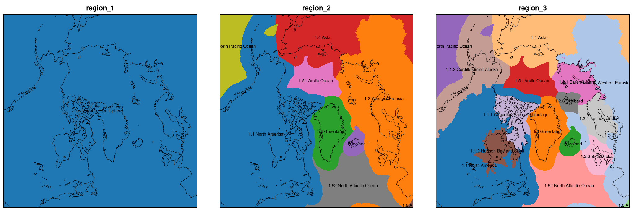
Codes and paths
A code has two digits per level below the first, so the path, level and ancestors of a region follow from its code. Ocean regions are numbered from 51.
@show region_code("1.1.2")
@show region_path(10102)
@show region_level(10102)
@show region_ancestor(10102, 2)
@show region_code("1.52");
region_code("1.1.2") = 10102
region_path(10102) = "1.1.2"
region_level(10102) = 3
region_ancestor(10102, 2) = 101
region_code("1.52") = 152A region with its subregions
in_region selects a region together with all its subregions. Comparing the codes of a level with == selects only the cells of the region that are in none of its subregions.
north_america = in_region(region_3, region_code("1.1"))   # with 1.1.1, 1.1.2, 1.1.3
rest = region_3 .== region_code("1.1")                    # only the cells in none of them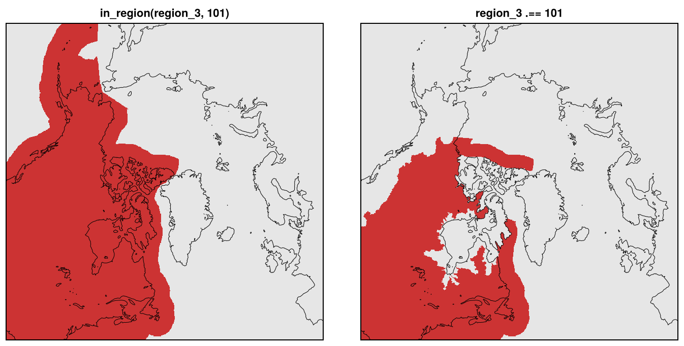
Zones and the shelf break
zone separates the open ocean (0), the open ocean within 50 km of the shelf break (1), the continental shelf (2) and land (3); dist_shelfbreak is the distance to the shelf break (km, positive in the open ocean), for other widths of the band along it. Combined with the regions, they give e.g. the shelf of a region.
zone = ds["zone"][:, :]
dist = ds["dist_shelfbreak"][:, :]

shelf = in_region(region_3, region_code("1.2")) .& (zone .== 2)   # shelf of Western Eurasia
band = 0 .< dist .< 200                                           # open ocean within 200 km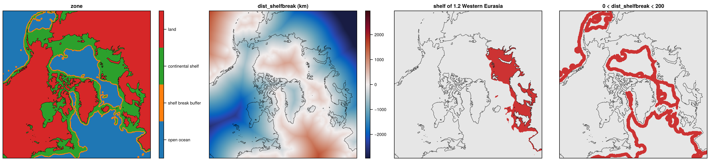
Basins
A basin set has the basins (basin), extended over the land and shelf of their region up to the shelf break, their groups (basin_group, if the set has them) and the original extent of the basins (basin_mask).
grl = joinpath(ENV["FESMDATA"], "products", "GreenlandPaleo", "GRL-PAL-16KM")
bs = NCDataset(joinpath(grl, "GRL-PAL-16KM_BASINS-Zwally2012.nc"))

basin = bs["basin"][:, :]
group = bs["basin_group"][:, :]
original = ifelse.(bs["basin_mask"][:, :] .== 1, basin, missing)   # before the extension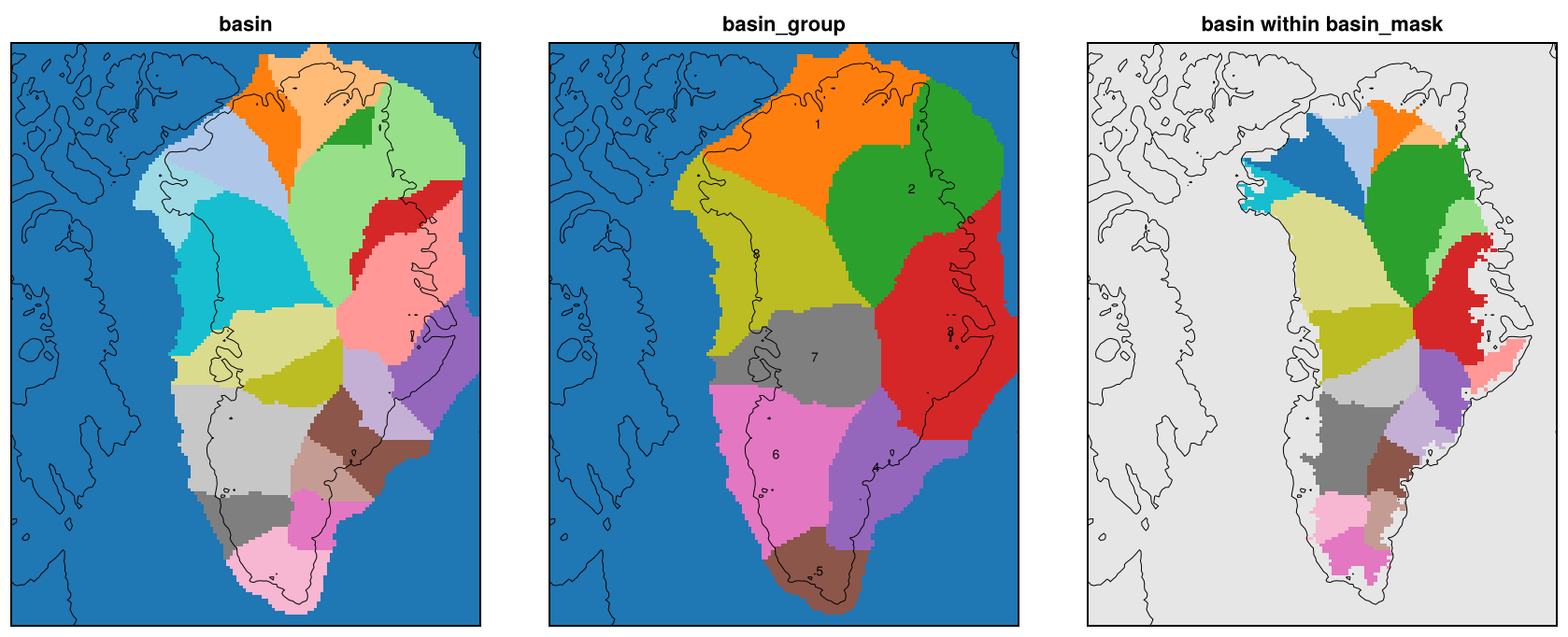
The same region on every domain
The tree is global, so a region has the same code on all domains and grids.
greenland = map(["North/NH-16KM", "GreenlandPaleo/GRL-PAL-16KM"]) do g
    file = joinpath(ENV["FESMDATA"], "products", g, basename(g) * "_REGIONS.nc")
    NCDataset(d -> in_region(d["region_2"][:, :], region_code("1.3")), file)
end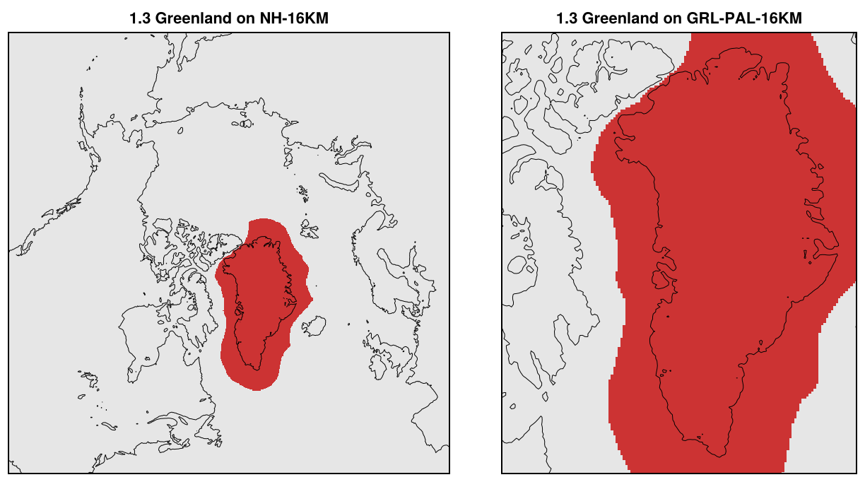
Antarctica: the tree, level by level
The same files on Antarctica: the levels of the tree of the ice sheet, its ice shelves and the Southern Ocean.
ant = joinpath(ENV["FESMDATA"], "products", "Antarctica", "ANT-16KM")
da = NCDataset(joinpath(ant, "ANT-16KM_REGIONS.nc"))
ant_regions = [da["region_$l"][:, :] for l in 1:3]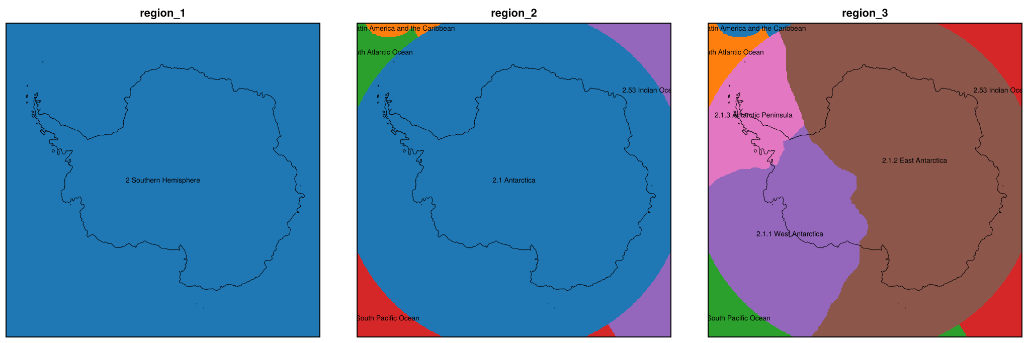
Antarctica: zones and basins
The zones of Antarctica and one of its basin sets, IMBIE2016 (the others are IMBIE2016-refined, Zwally2012 and Schmidt2025).
ant_zone = da["zone"][:, :]
ab = NCDataset(joinpath(ant, "ANT-16KM_BASINS-IMBIE2016.nc"))
ant_basin = ab["basin"][:, :]